Tectonic Deformation
Oblique convergence and slip partitioning in the NW Hiamalaya : Implications from GPS measurements
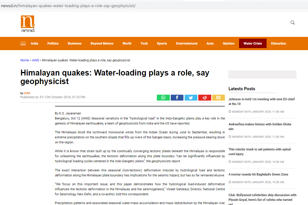
We report GPS measurements of crustal deformations across the Kashmir Himalaya. We combined these results with published results of GPS measurements from the Karakoram Fault system and suggest that in Kashmir Himalaya, the motion between the Southern Tibet and India plate is oblique with respect to the structural trend. We estimated this almost north-south oblique motion to be 17 +/- 2 mm/yr, which is partitioned between dextral motion of 5 +/- 2 mm/yr on the Karakoram fault system and oblique motion of 13.6 +/- 1 mm/yr with an azimuth of N198°E in the northwest-southeast trending Kashmir...
Kundu et al., 2014 MORE
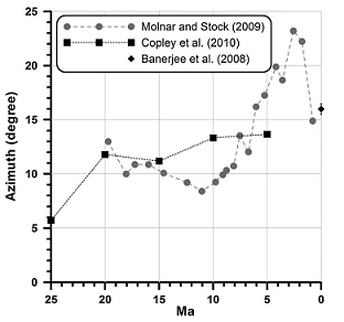
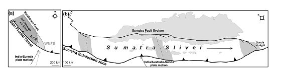
Oblique convergence and strain partitioning in the outer deformation front of NE Himalaya
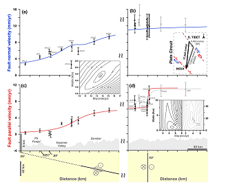
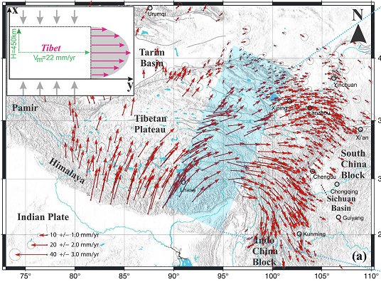
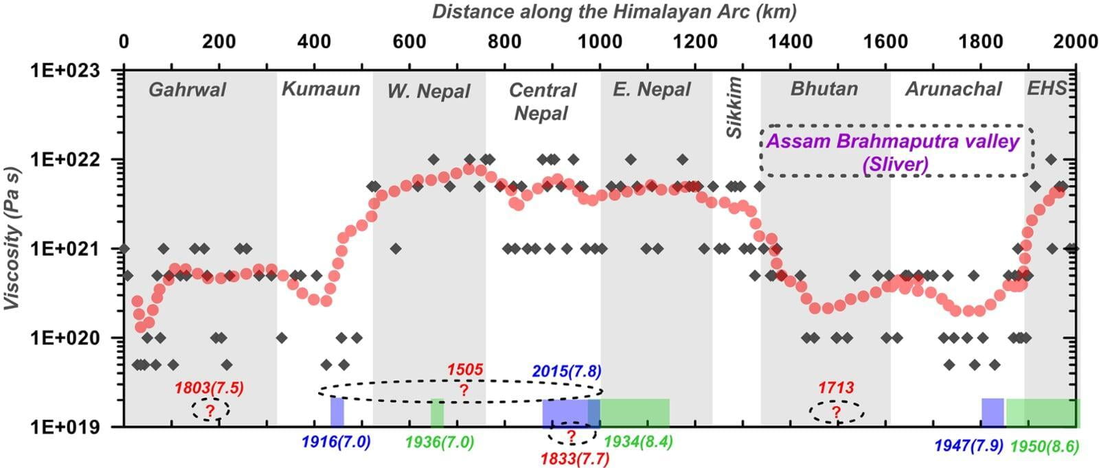
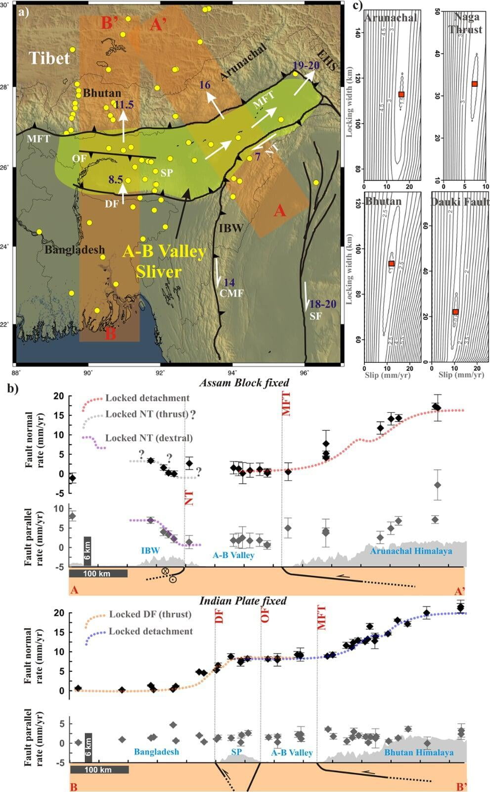
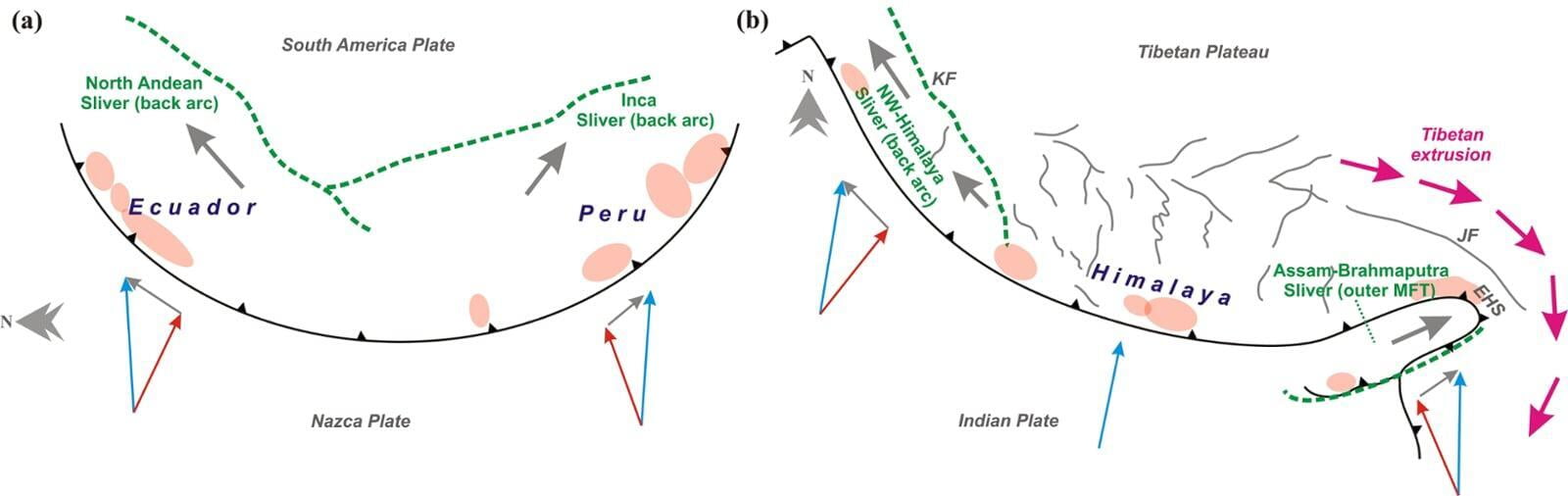
Himalayan-Tibetan orogeny has considered as a natural black box in the context of geodynamic evolution and tectonic complexity. The eastward extrusion model of Tibetan crust contradicts with the oblique convergence model in the NE-Himalaya (Bhutan/Arunachal region), where the overall convergence rate accommodated in the Himalaya is about 20–25% less than that in the neighbouring central Himalaya and Eastern Himalayan syntaxis (EHS). We propose that instead of partitioning in the backarc, the NE-Himalaya has developed an active sliver along the Assam-Brahmaputra valley in the outer deformation front, in order to accommodate the deficiency in long-term plate convergence between Himalaya and southern Tibet. We argue that the strong eastward extrusion of ...
Panda et al., 2018 MORE
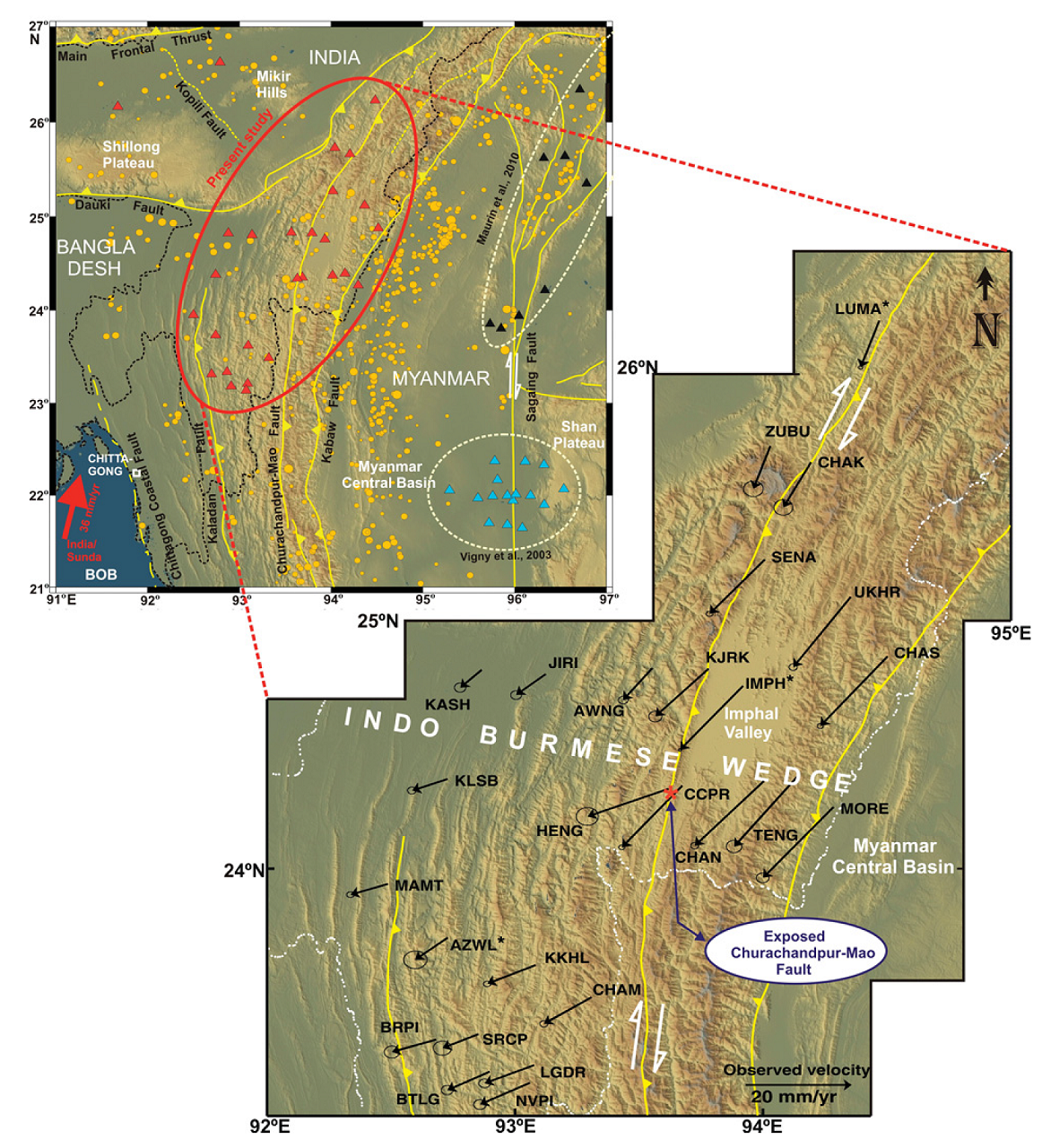
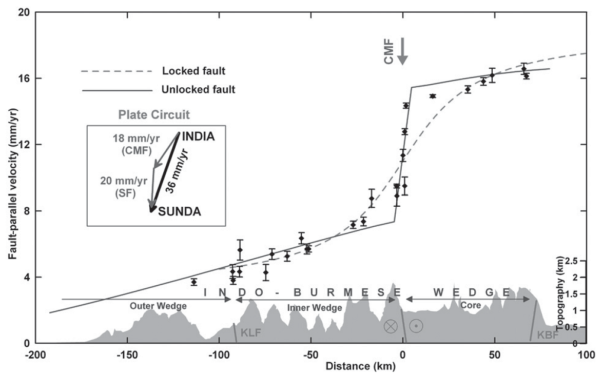
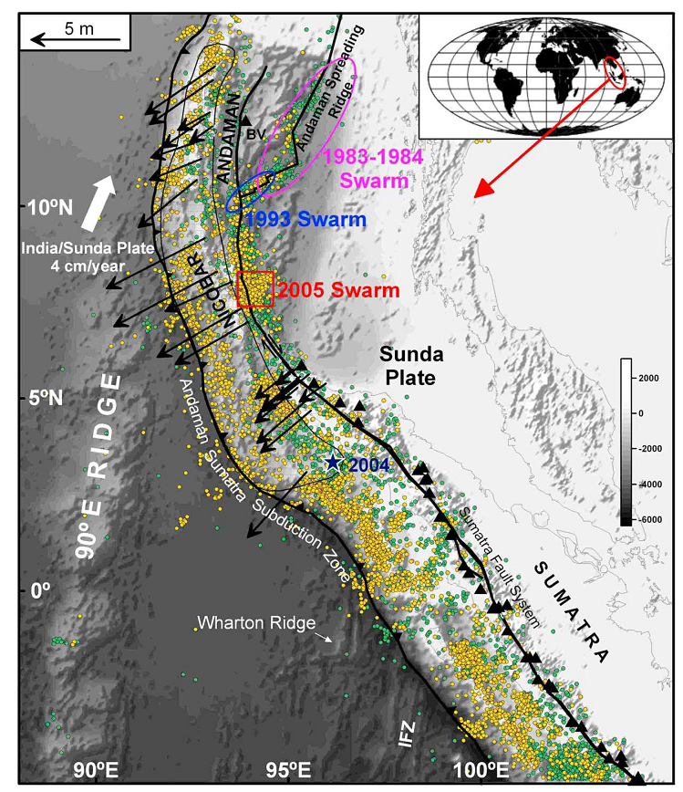
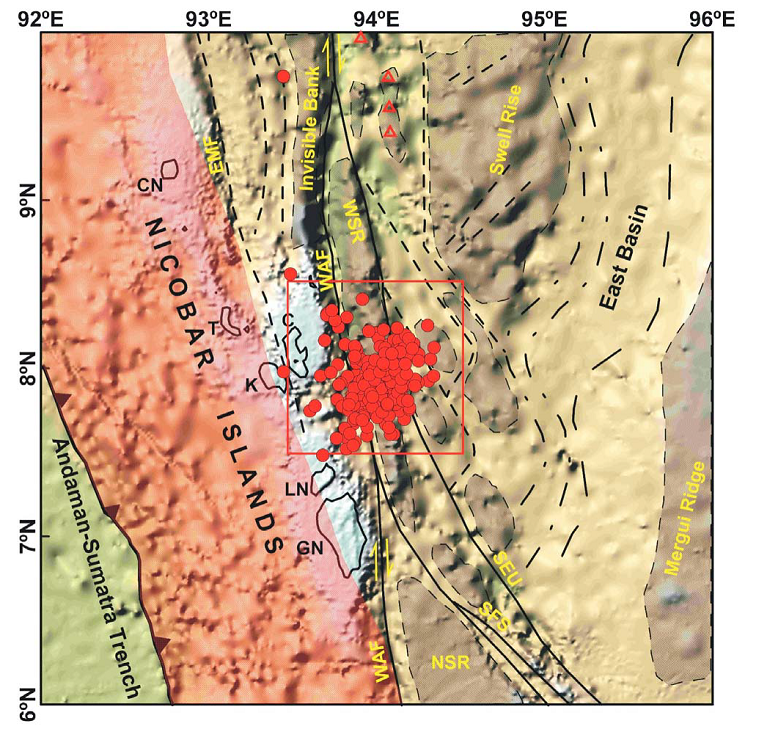
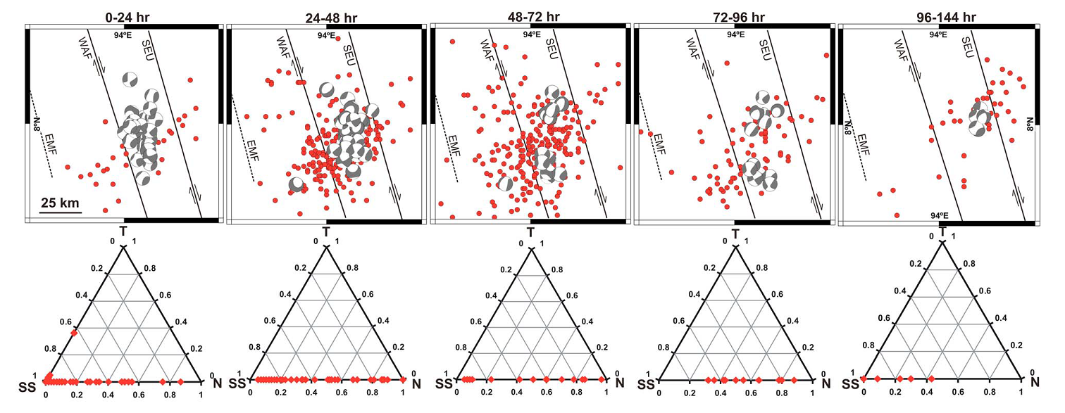
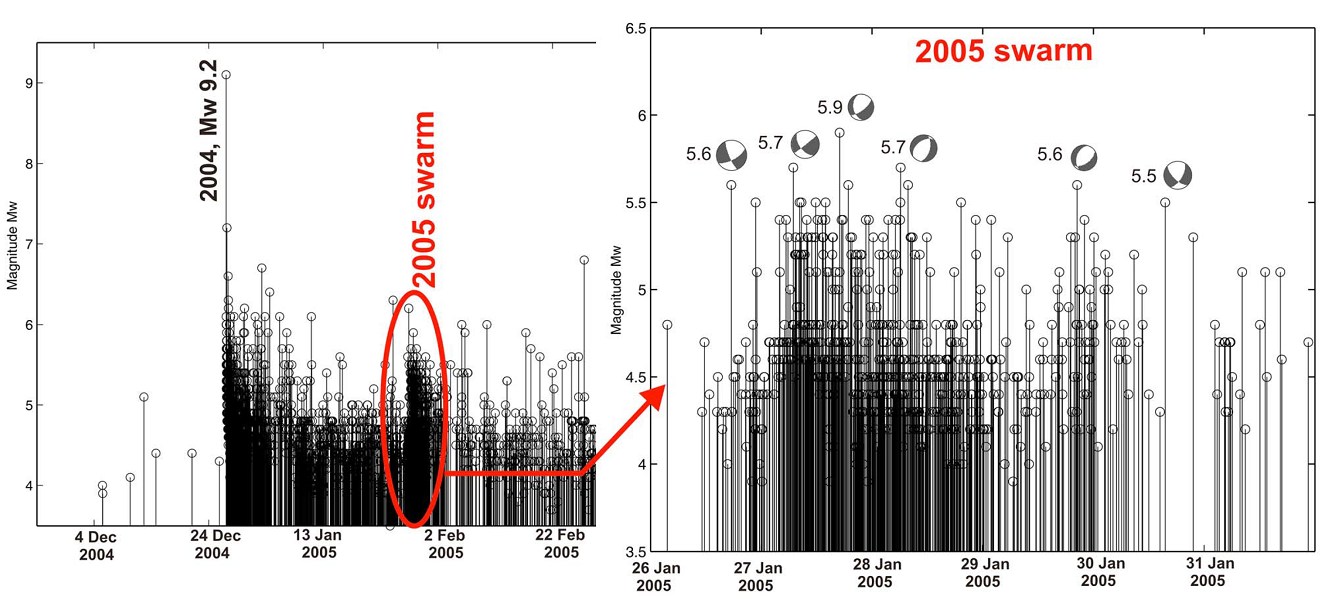
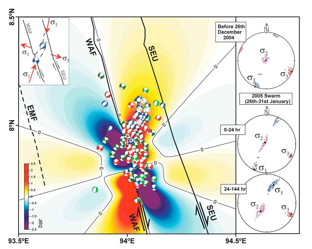
Aseismic plate boundary in the Indo-Burmese wedge, northwest Sunda Arc
Plate motion, crustal deformation, and earthquake occurrence processes in the northwest Sunda Arc, which includes the Indo-Burmese wedge (IBW) in the forearc and the Sagaing fault in the backarc, are very poorly constrained. Plate reconstruction models and geological structures in the region suggest that subduction in the IBW occurred in the geological past, but whether it is still active and how the plate motion between the India and Sunda plates is partitioned between motion in the IBW and Sagaing fault is largely unknown. Recent GPS measurements of crustal deformation and available long-term rates of motion across the Sagaing fault suggest that ∼20 ± 3 mm/yr of the relative plate motion of ∼36 mm/yr between the India and Sunda plates is accommodated at the Sagaing fault through dextral strike-slip motion. We report results from a dense GPS network in the IBW that has operated since 2004. . Our analysis of these measurements and the ...
Gahalaut et al., 2013 MORE
Volcanic Deformation
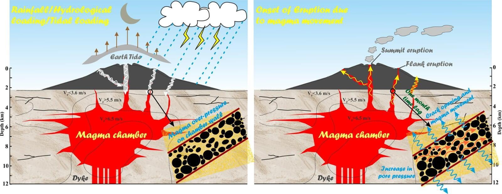
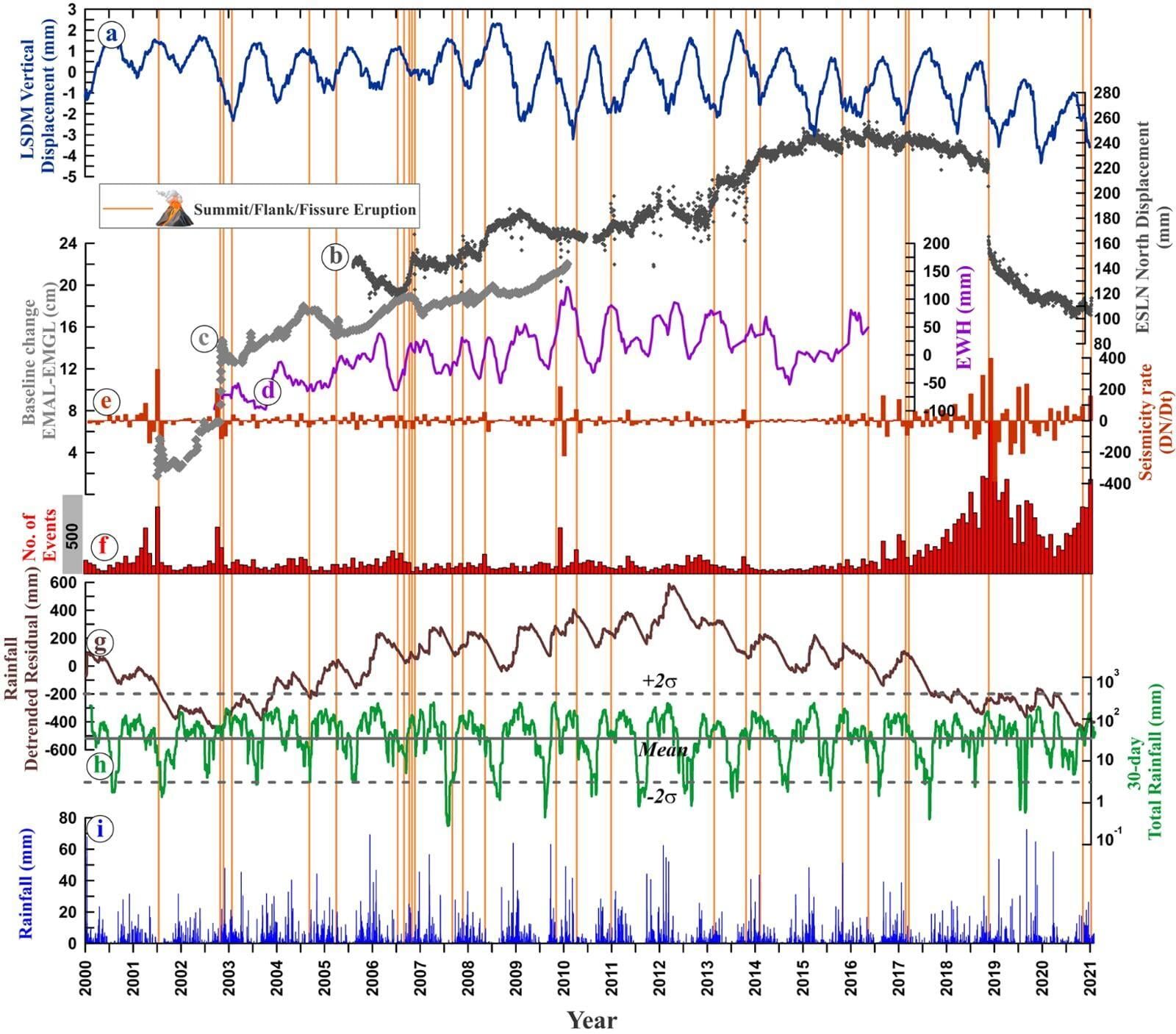
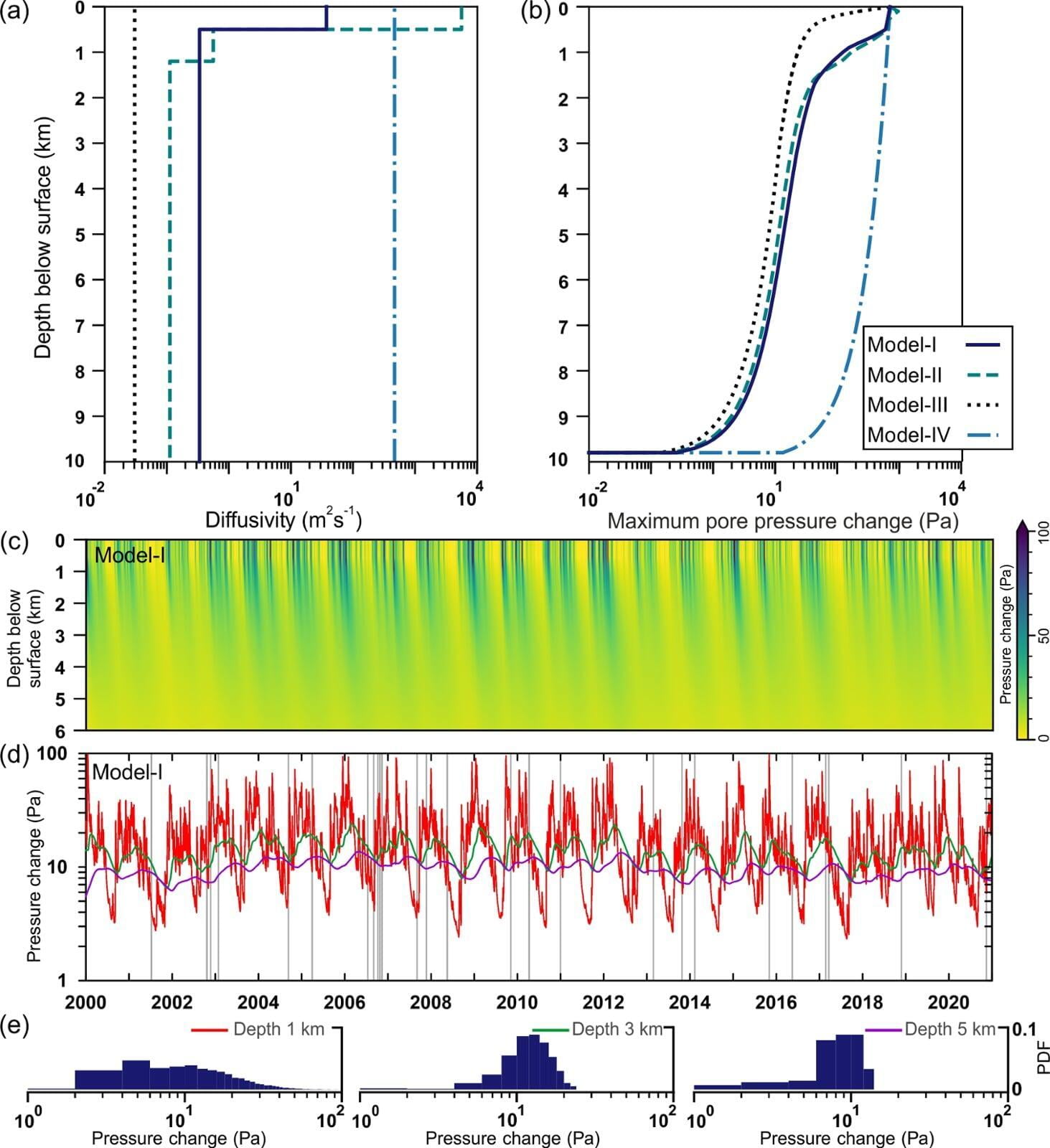
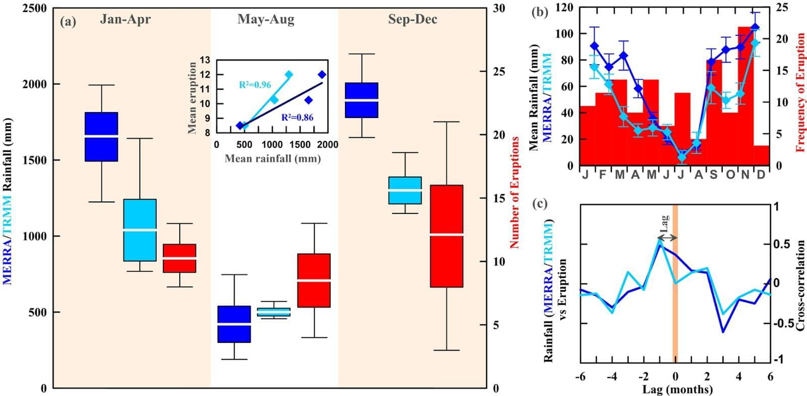
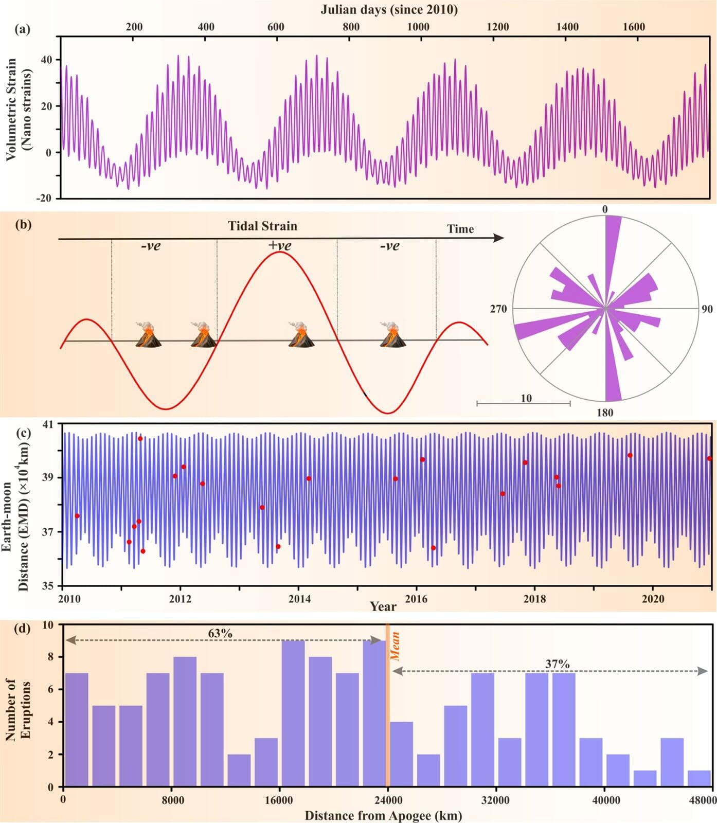
Eruption cycles of Mount Etna triggered by seasonal climatic Rainfall
The ability to mitigate and predict volcanic risk is a long-standing question in the Geosciences’ community, while the extent of volcanic activity may be regulated by a predictable and periodic external excitation induced by seasonal rainfall, hydrological loading, or Moon-Sun gravitational force. Moreover, the complex stress-triggering, hydro-mechanical coupling in response to seasonal rainfall, and associated feedback mechanism with deep magmatic process remains enigmatic and indeed deserves more attention in view of recent climate change scenario. In this letter, a compelling scenario of seasonal rainfall-triggered eruption cycles of Mount Etna (Italy) is found and presented on the eastern coast of Sicily with continuously erupting since last 200 kyr. Results show that the seasonal rainfall significantly weakened the Mount Etna edifice and initiated mechanical tensile failure in the complex magmatic plumbing system and adjacent flank surface by changing the pore pressure build-up, probably promoting dyke intrusion and eventual triggering of eruptive cycle. Further, the possibility of seasonal hydrological loading on the Mount Etna volcano and adjacent flank region, hydrological load-induced sliding along the impermeable outer ‘shell’ of the flank are discussed, and the effect of tidal stress perturbations on the eruptions cycle cannot be ruled out completely.
Sahoo et al., 2022 MORE
Kundu et al., 2012 MORE
Kundu et al., 2020 MORE
Climate Induced Deformation
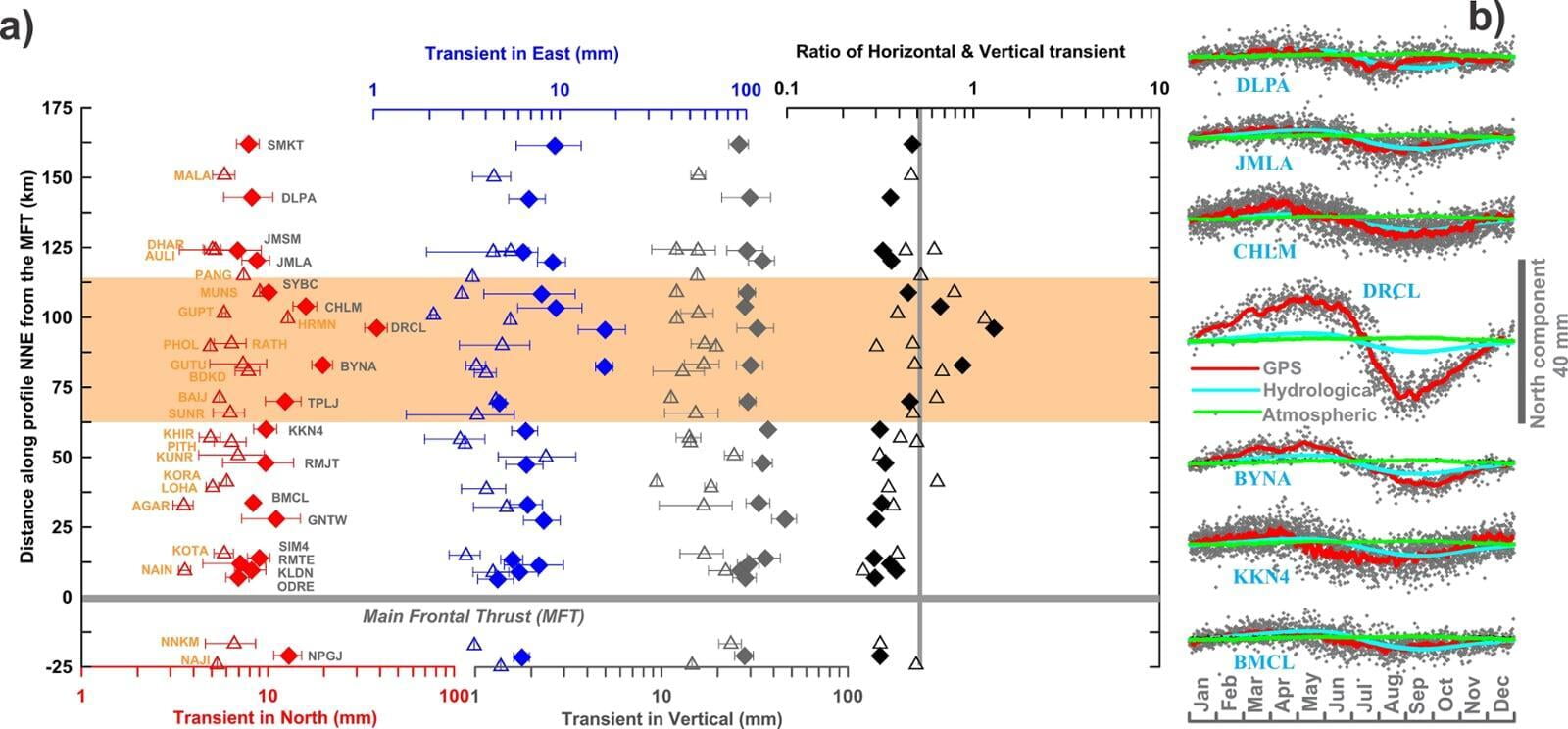
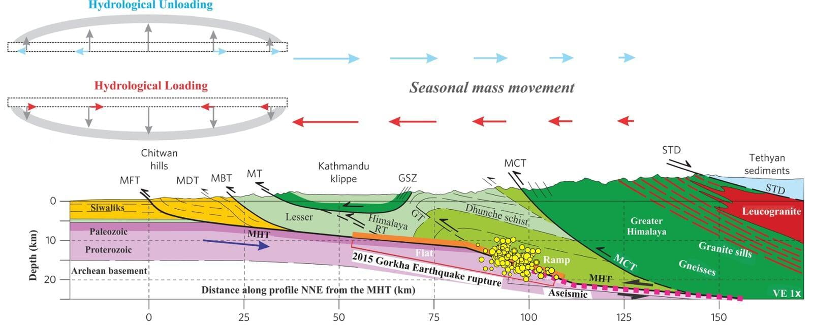
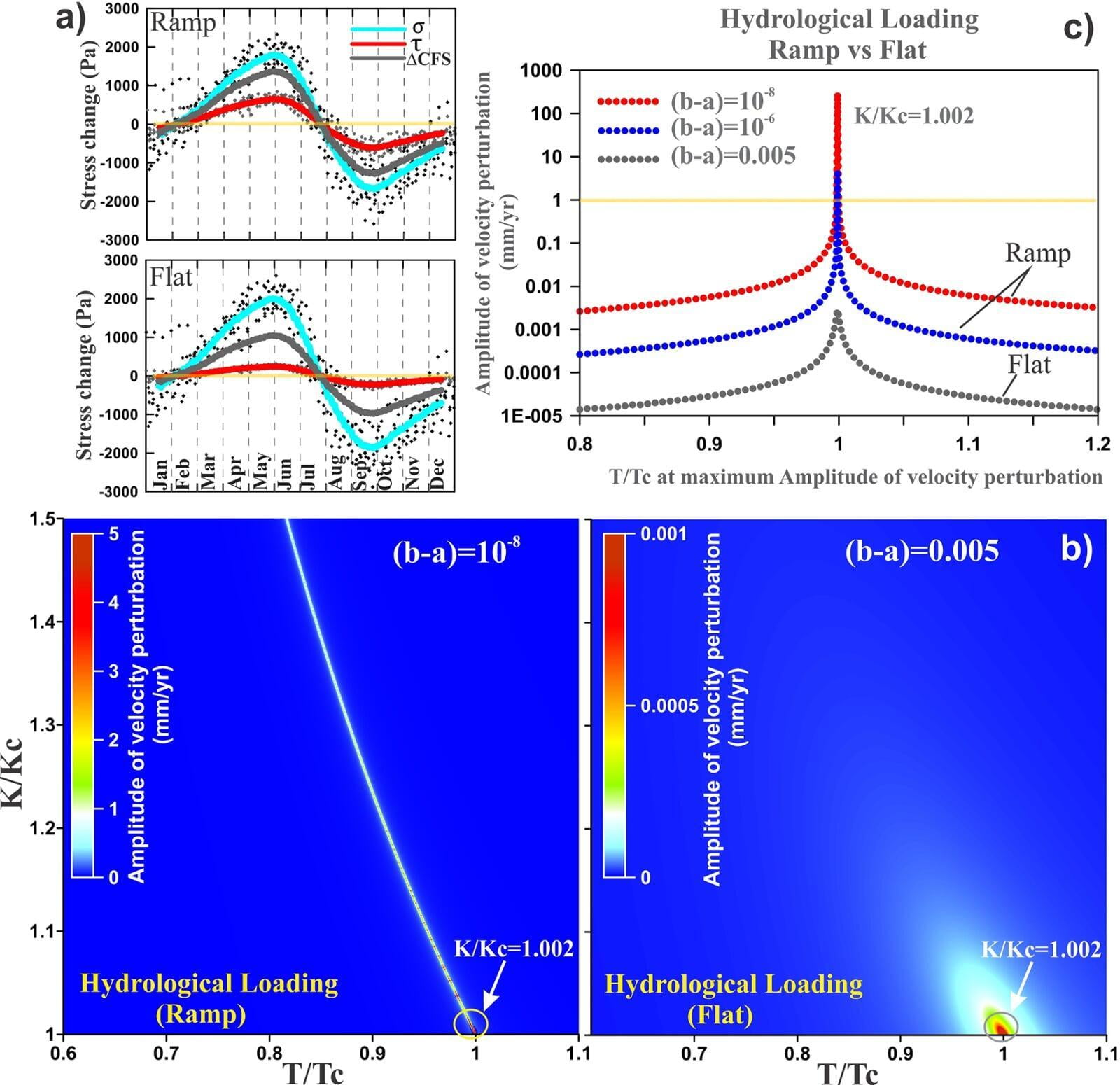
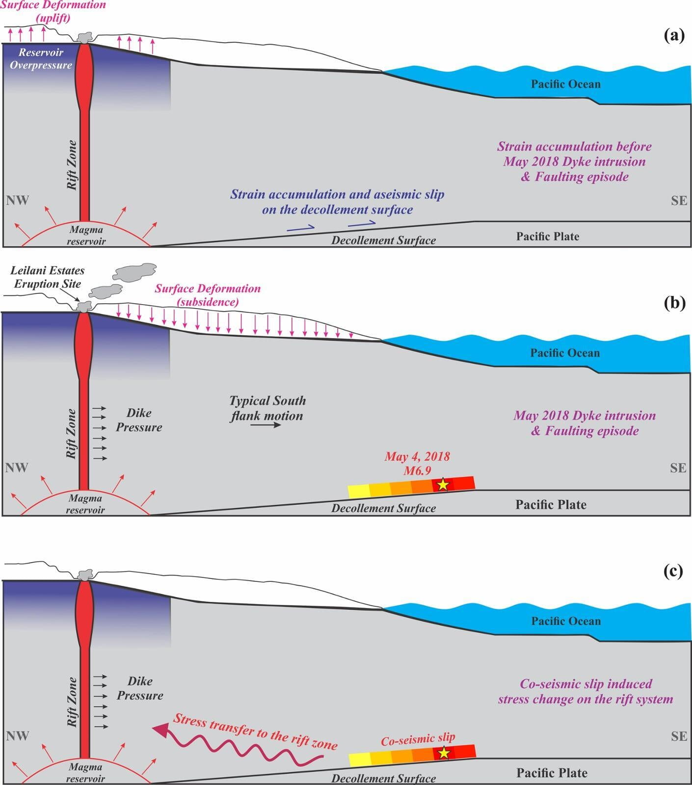
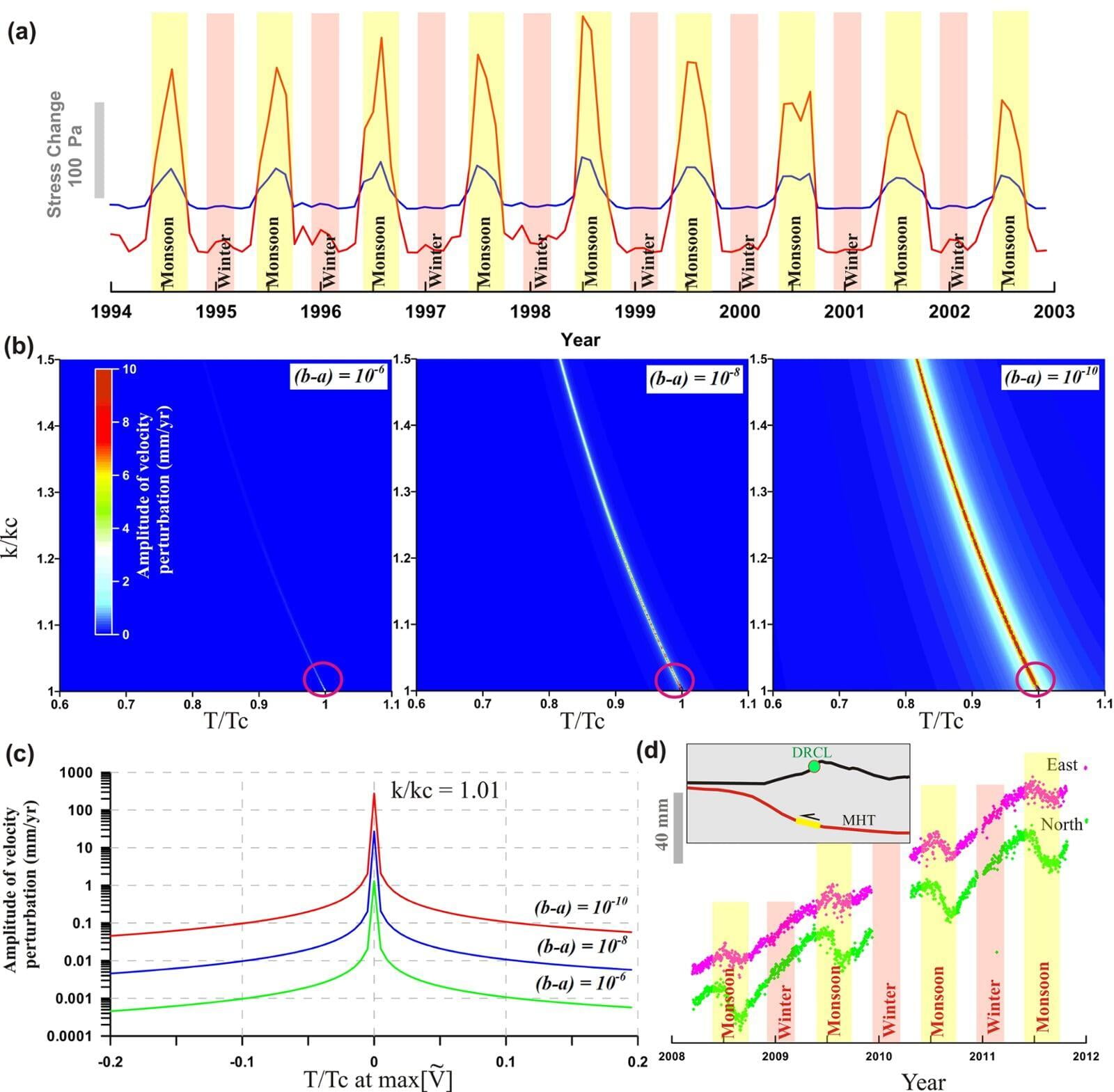
Seasonal modulation of deep slow-slip and earthquakes on the Main Himalayan Thrust
The interaction between seasonally-induced non-tectonic and tectonic deformation along the Himalayan plate boundary remains debated. Here, we propose that tectonic deformation along this plate boundary can be significantly influenced by the deformation induced by the non-tectonic hydrological loading cycles. We explore seasonal mass oscillations by continental water storage in Southeast Asia and Himalayan arc region using continuous Global Positioning System measurements and satellite data from the Gravity Recovery and Climate Experiment. We suggest that the substantially higher transient displacements above the base of the seismogenic zone indicate a role of changes in aseismic slip rate on the deep megathrust that may be controlled by seasonal hydrological loading.We invoke modulation of aseismic slip on the megathrust down-dip...
Panda et al., 2018 MORE
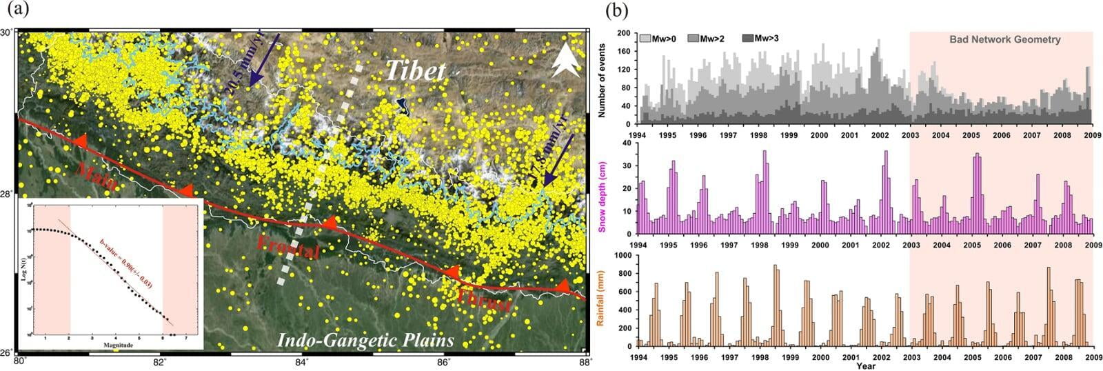
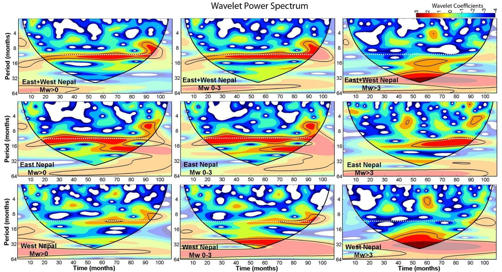
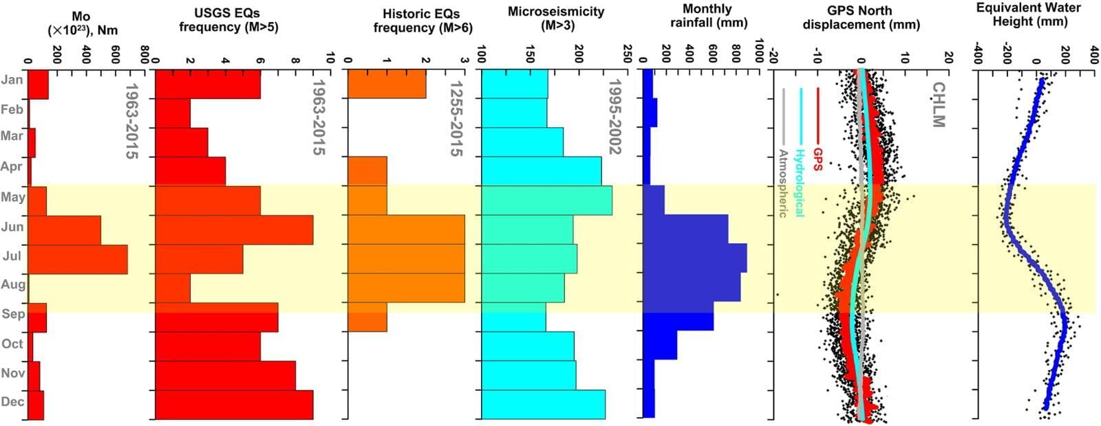
Influence of a meteorological cycle in mid-crustal seismicity of the Nepal Himalaya
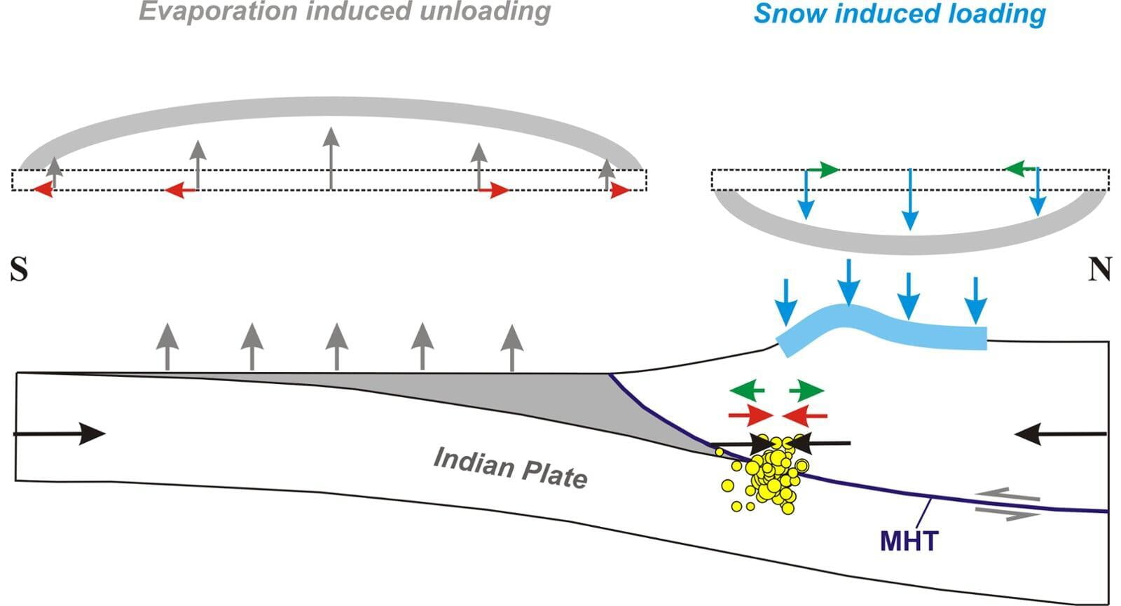
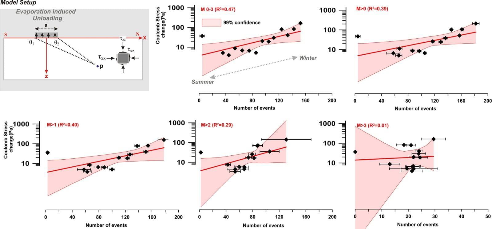
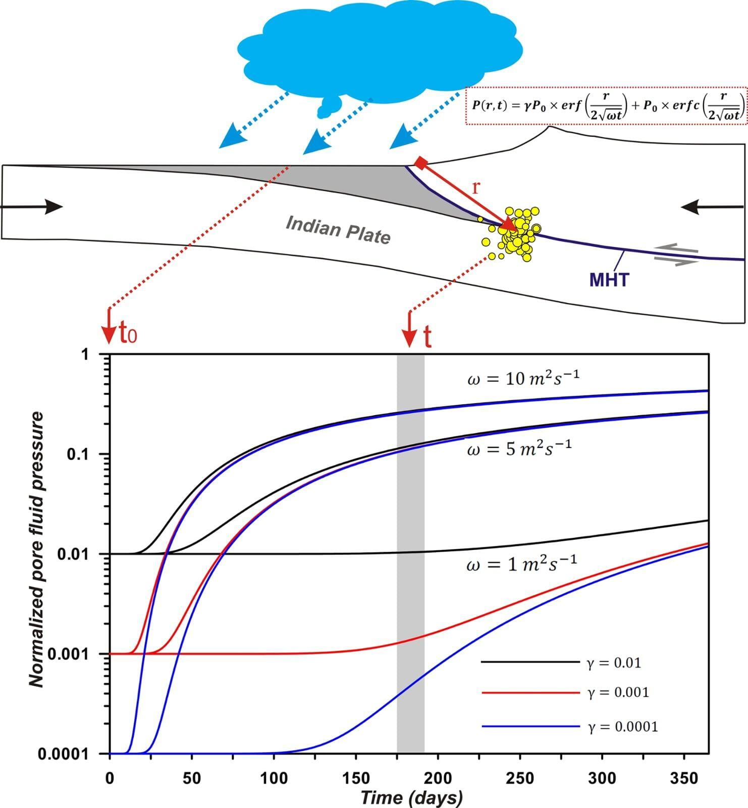
The process of interseismic strain accumulation across the Nepal Himalaya is associated with micro seismicity (also called mid-crustal seismicity) which occurs along the mid-crustal ramp on the Main Himalayan Thrust (MHT). The seismicity shows strong annual periodicity in response to the annual stress variation of hydrological loads. We report dominance of annual periodicity in the eastern Nepal as compared to that of western Nepal, and overall annual periodicity dominance in the small magnitude earthquakes (Mw 0–3). Rainfall seismicity crosscorrelation is significantly higher in the eastern Nepal region as compared to that of western Nepal with a prominent phase lag of 5–6 months with respect to the occurrence of monsoonal rainfall. Seasonal modulation can be explained by Coulomb failure stress model and fault resonance hypothesis induced by meteorological....
Kundu et al., 2017 MORE
Human Induced Deformation
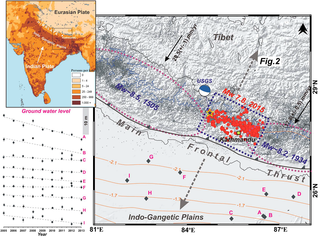
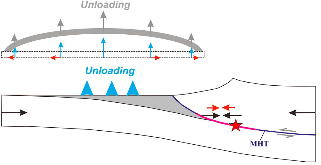
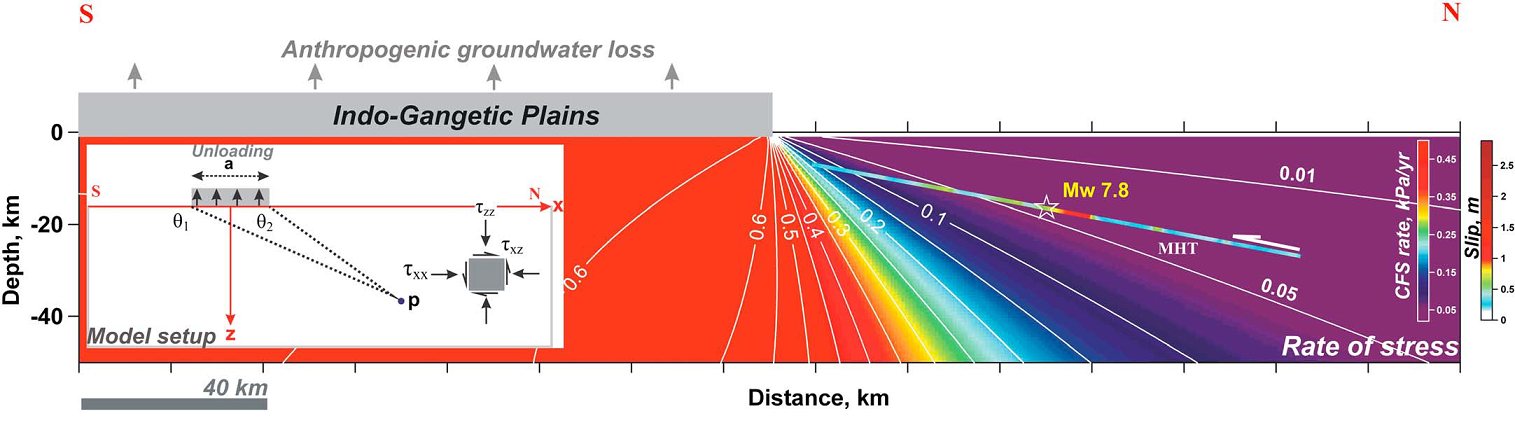
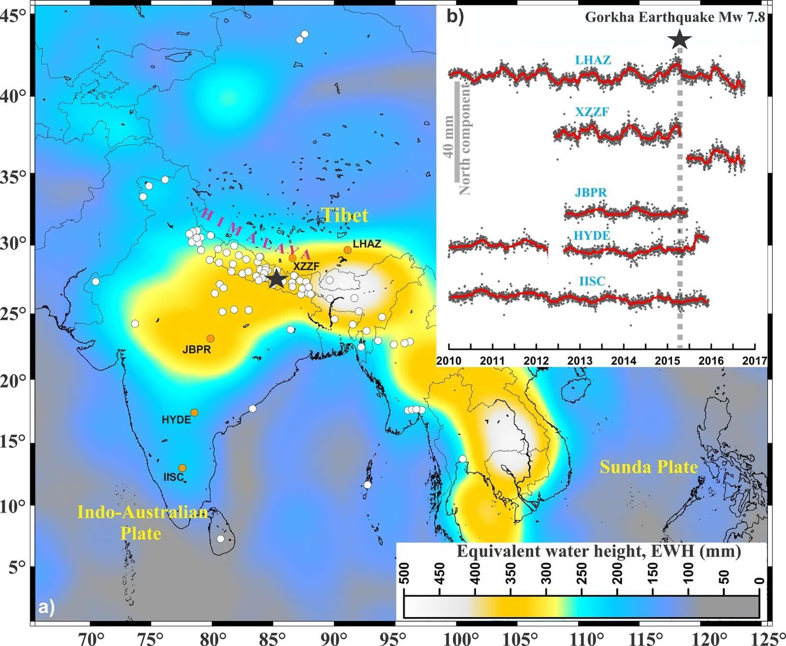
Influence of anthropogenic groundwater unloading in Indo-Gangetic plains on the 25 April 2015 Mw 7.8 Gorkha, Nepal earthquake
Groundwater usage in the Indo-Gangetic plains exceeds replenishment of aquifers, leading to substantial reduction in the mass. Such anthropogenic crustal unloading may promote long-term fault slip or may modulate seismic activity in the adjoining Himalayan region. Our simulation using Gravity Recovery and Climate Experiment data and hydrological models of such a process indicates that the thrust earthquakes on the Main Himalayan Thrust (MHT), including the recent 25 April 2015 Mw 7.8 Gorkha, Nepal earthquake, are probably influenced by the anthropogenic groundwater unloading process in the Gangetic plains. The groundwater withdrawal leading to crustal unloading in the Gangetic plains causes a significant component of horizontal compression which adds to the secular interseimic compression at the seismogenic depth (5–20 km) on the MHT beneath the Himalayan.....
Kundu et al., 2015 MORE
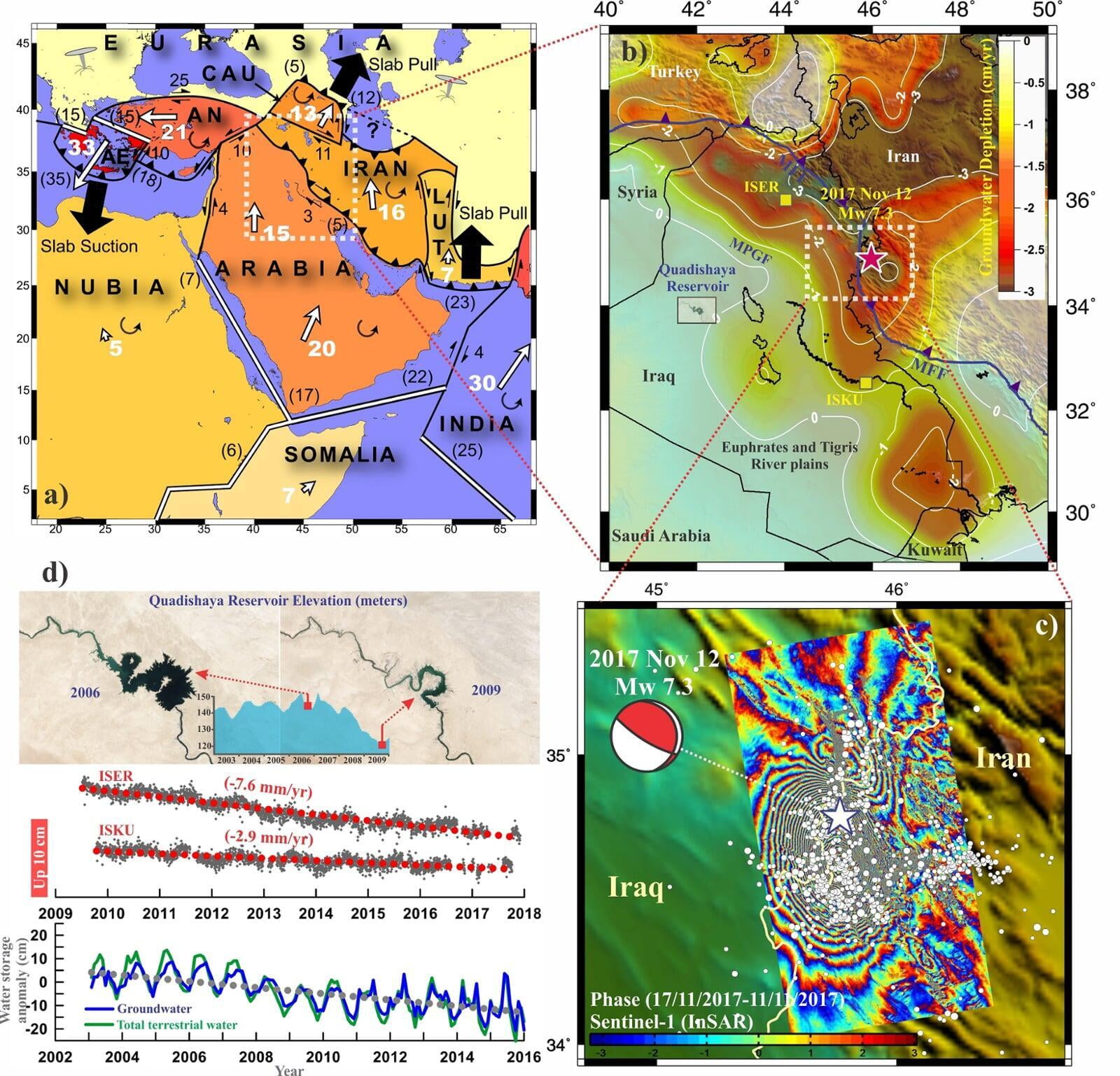
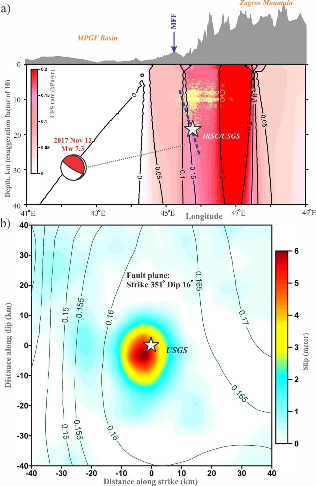
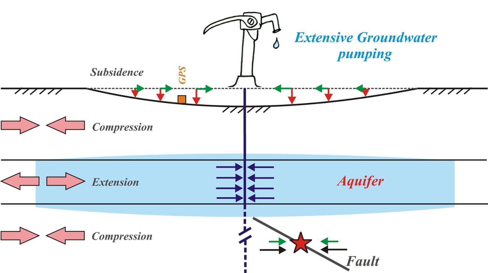
Influence of anthropogenic groundwater pumping on the 2017 November 12M7.3 Iran–Iraq border earthquake
Study of induced, triggered, stimulated and nuance earthquakes can provide a unique opportunity to probe into stress/frictional conditions on the subsurface fault. Although mechanism of faulting is tectonically driven phenomenon, anthropogenic crustal (un-)loading process can also drive long-term fault slip or modulate seismicity in the nearby seismogenic crust. Using Gravity Recovery and Climate Experiment data, surface subsidence rate captured by cGPS and 3-D hydrological stress models, we report that the 2017 November 12 M7.3 Iran–Iraq border earthquake in the Arabia–Eurasia collision boundary region of the Zagros fold-and-thrust belt was significantly influenced by the anthropogenic groundwater unloading in the Euphrates and Tigris River plains and western Iran, a region which is probably the most intensely irrigated region in the Middle East. We find that the anthropogenic crustal unloading contributed about one tenth of the secular interseismic stress change rate due to tectonic loading. Thus, the resulting cumulative stress accumulation was significantly influenced by the extensive groundwater pumping......
Kundu et al., 2019 MORE
Atmospheric Disturbances
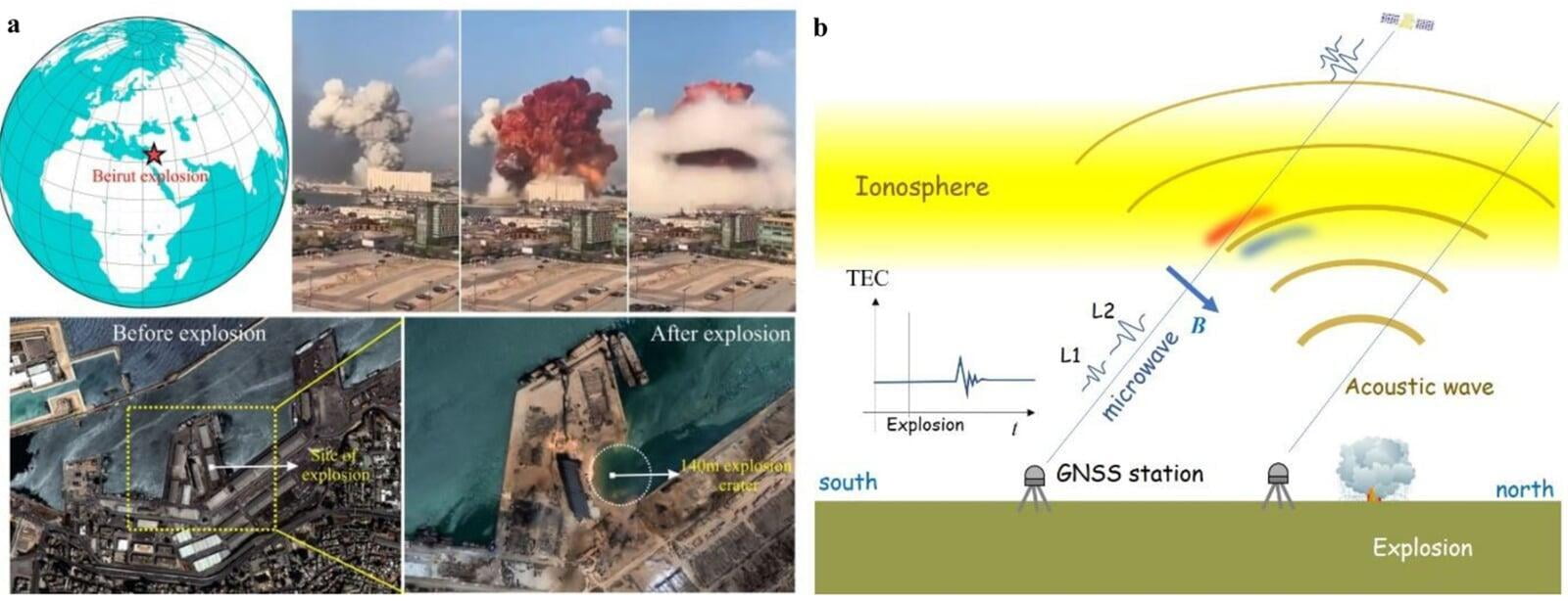
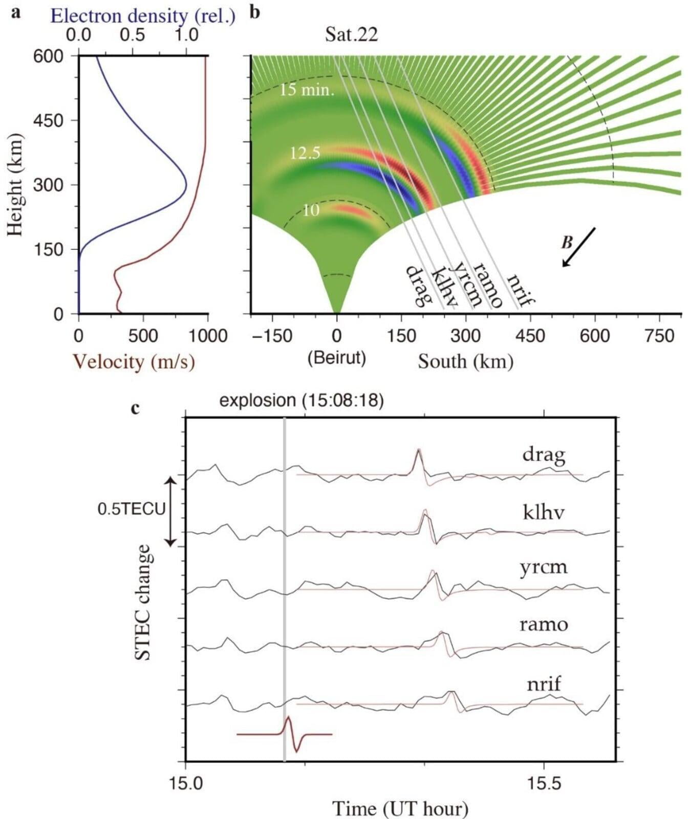
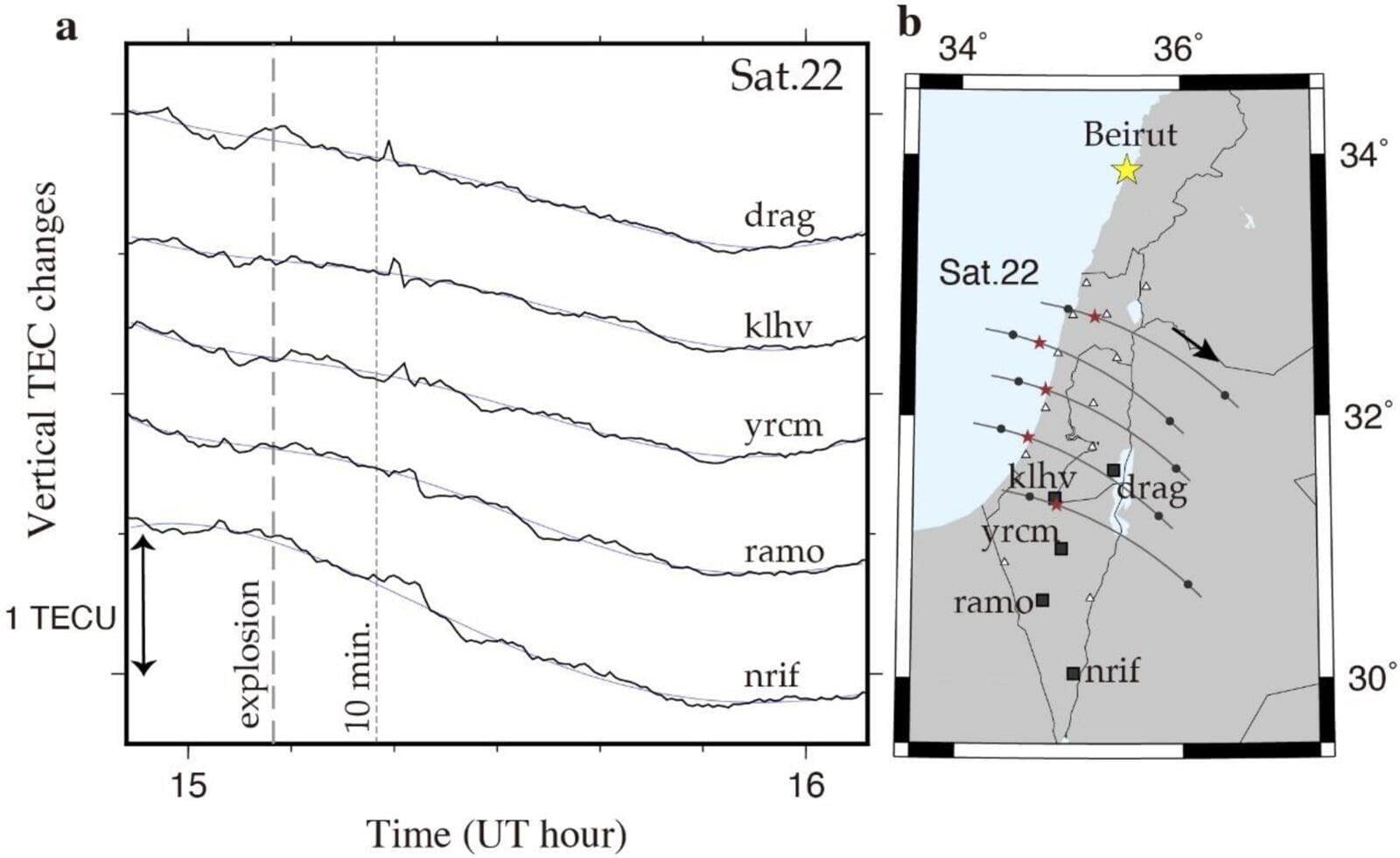
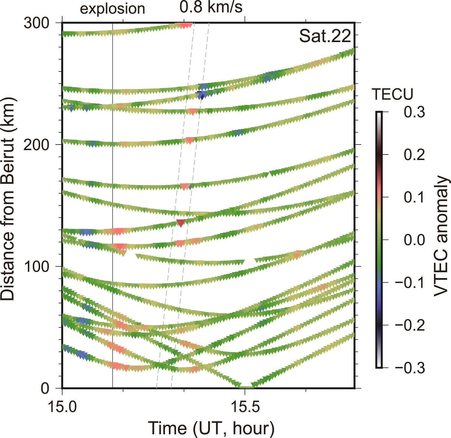
Atmospheric wave energy of the 2020 August 4 explosion in Beirut, Lebanon, from ionospheric disturbances
Atmospheric waves excited by strong surface explosions, both natural and anthropogenic, often disturb upper atmosphere. In this letter, we report an N-shaped pulse with period ~ 1.3 min propagating southward at ~ 0.8 km/s, observed as changes in ionospheric total electron content using continuous GNSS stations in Israel and Palestine, ~ 10 min after the August 4, 2020 chemical explosion in Beirut, Lebanon. The peak-to-peak amplitude of the disturbance reached ~ 2% of the background electrons, comparable to recently recorded volcanic explosions in the Japanese Islands. We also succeeded in reproducing the observed disturbances assuming acoustic waves propagating upward and their interaction with geomagnetic fields.
Kundu et al., 2021 MORE
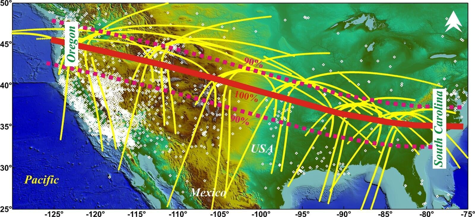
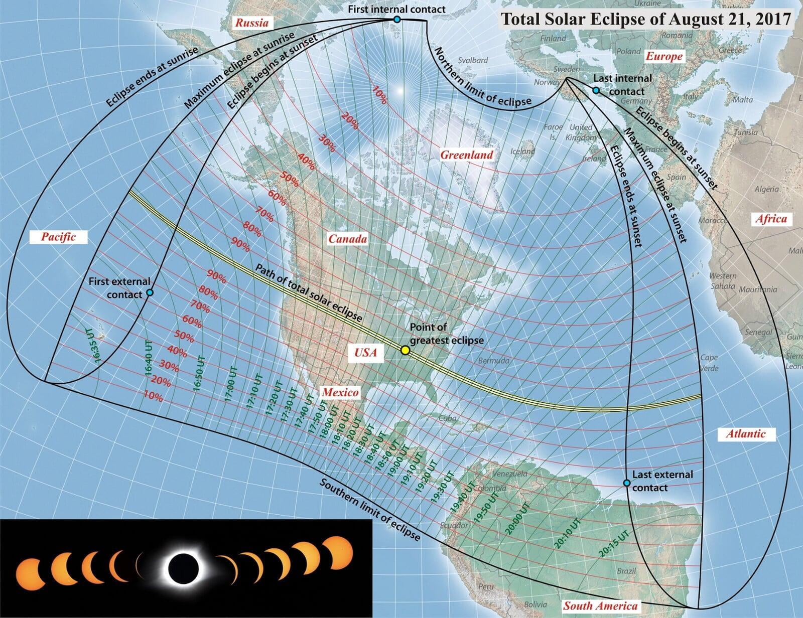
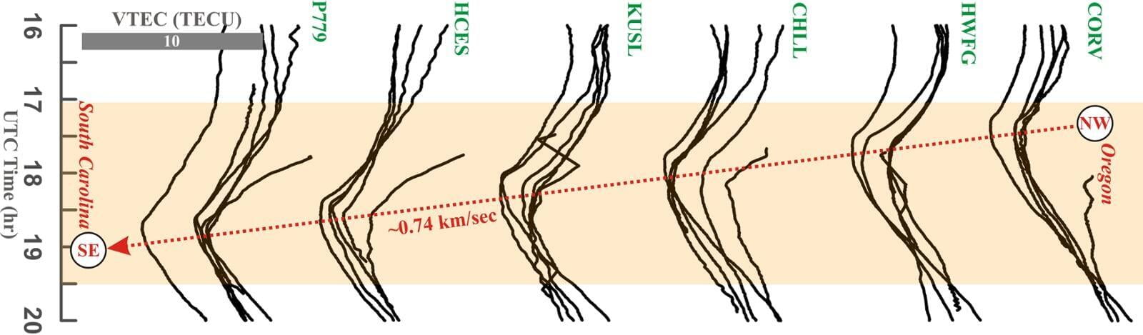
The 2017 August 21 American total solar eclipse through the eyes of GPS
We explored spatio-temporal variation in total electron contents (TEC) in the ionosphere caused by the recent 2017 August 21 total solar eclipse, which was observed over the United States of America. The path of the total solar eclipse passes through the continental parts of the United States of America, starting in the northwestern state of Oregon and ending in the southeastern state of South Carolina, approximately covering 4000 km length. Across this length, EarthScope Plate Boundary Observatory (PBO) has been operating a dense Global Navigation Satellite Systems (GNSS) networks. During the course of passage of the solar eclipse, the sudden decline in solar radiation by temporarily obscuration by the Moon caused a drop of ∼6–9 × 10¹⁶ electrons m2 in the ionosphere with time-delay at the cGPS sites. The significant drop in TEC at cGPS sites captured the average migration velocity of shadow along the eclipse path......
Kundu et al., 2018 MORE
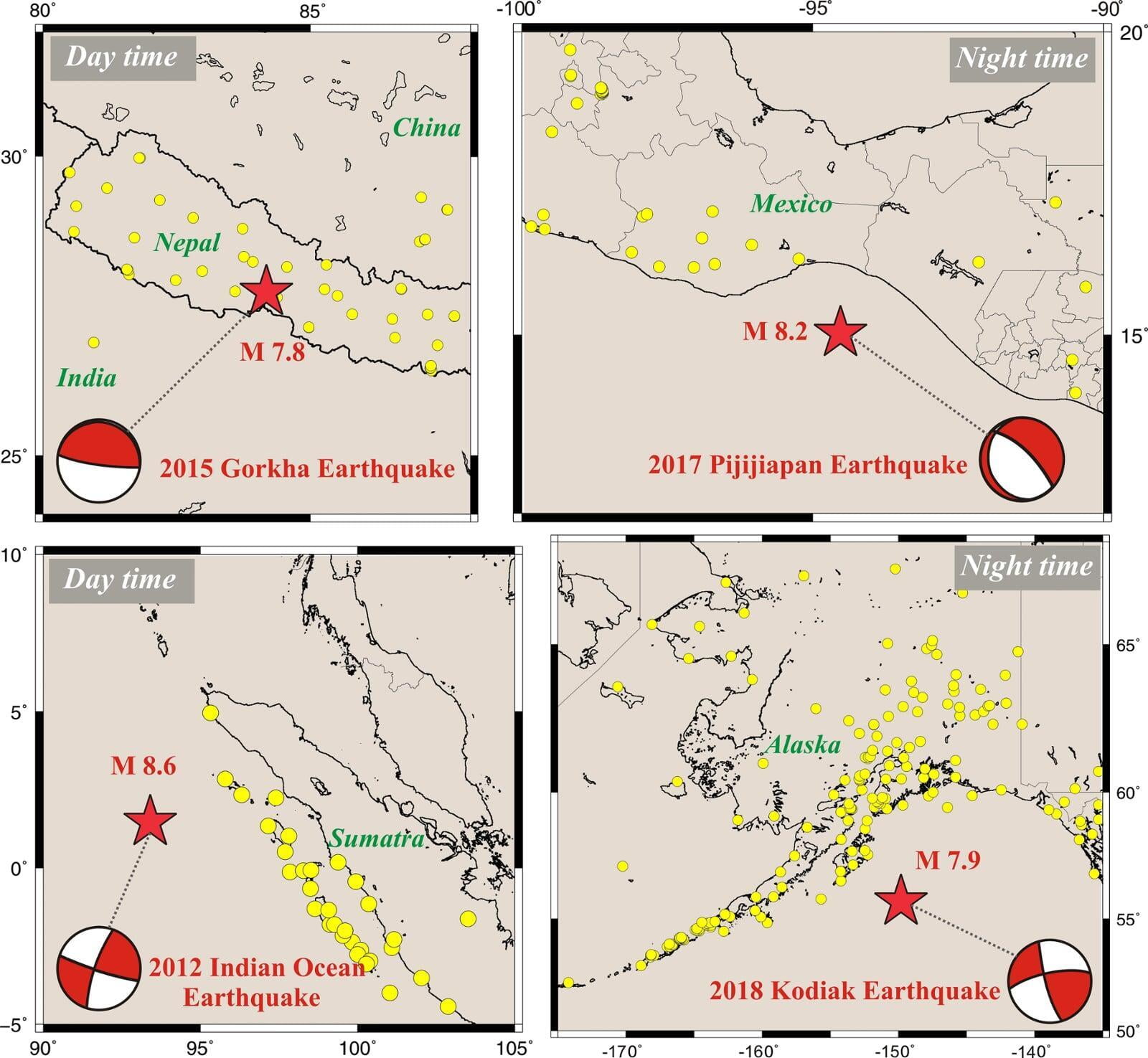
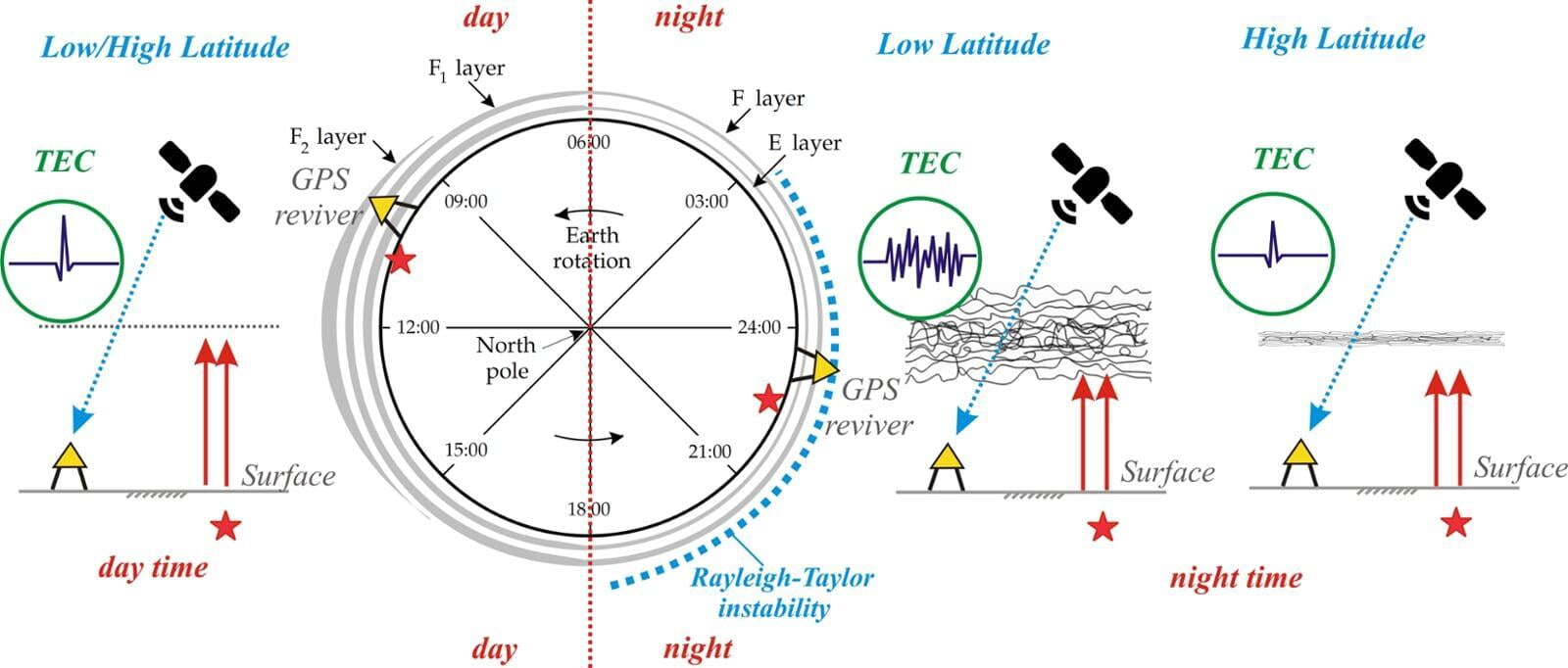
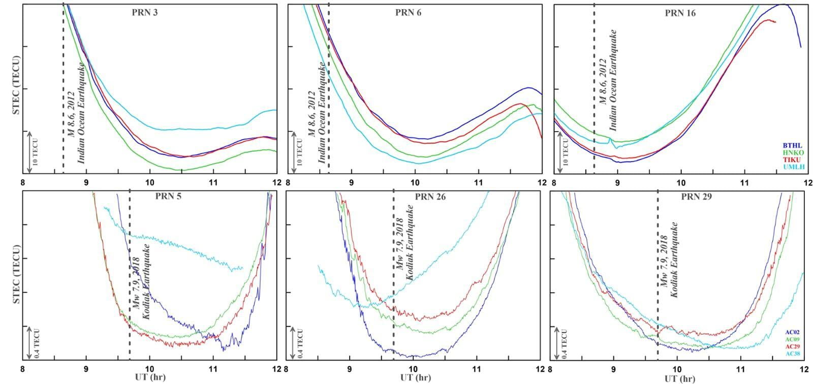
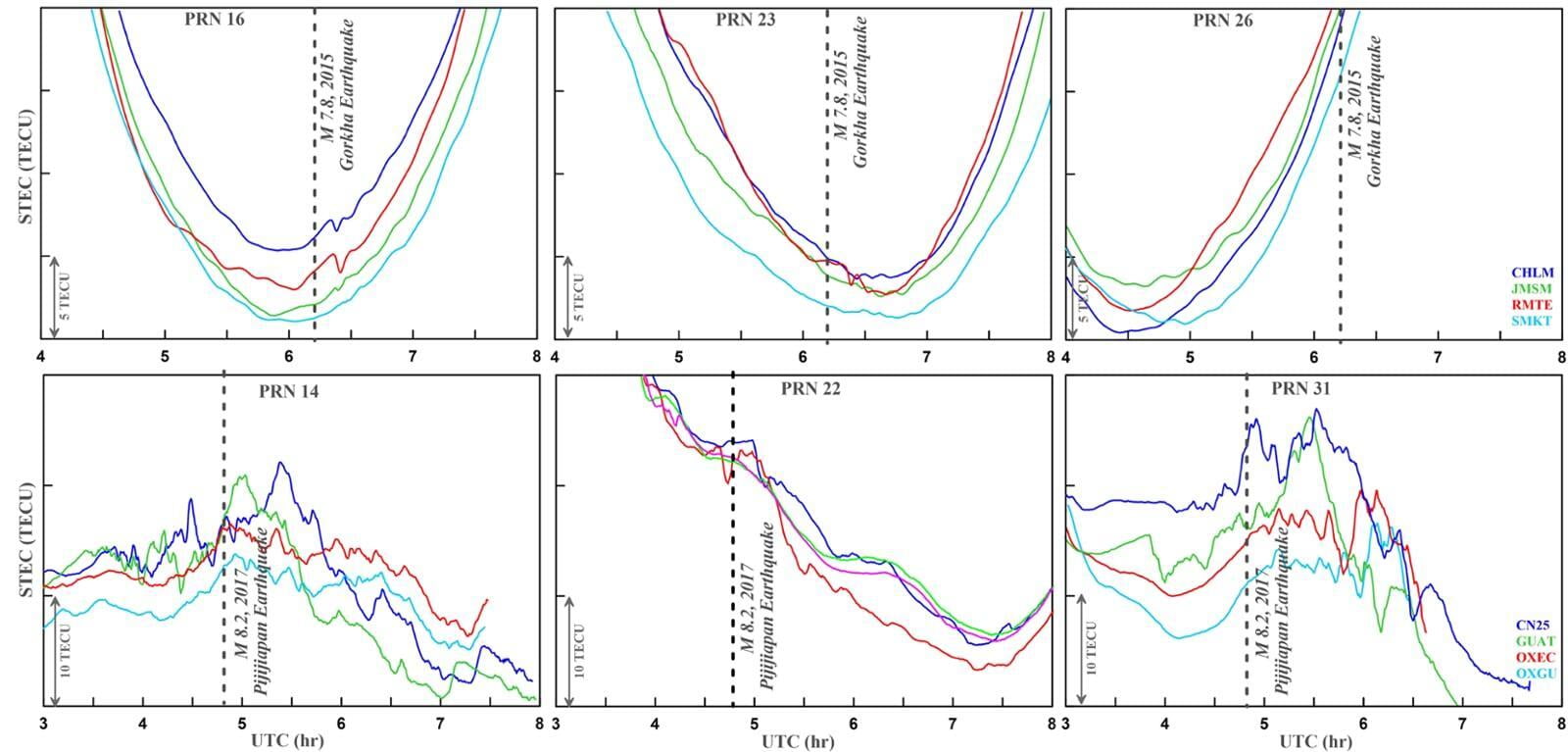
Effects of Rayleigh-Taylor instability and ionospheric plasma bubbles on the global navigation satellite System signal
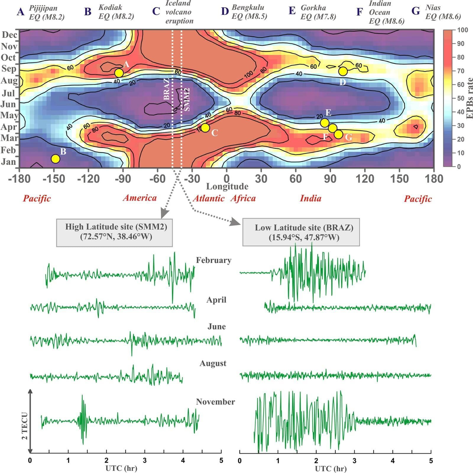
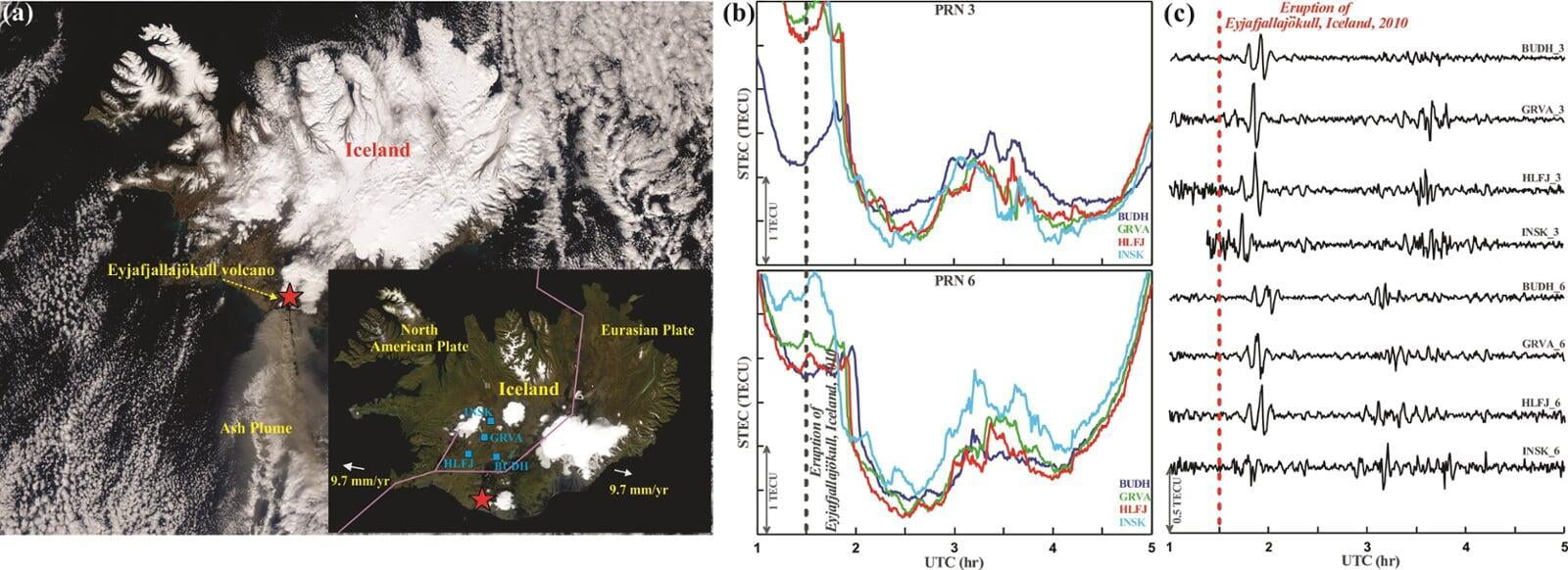
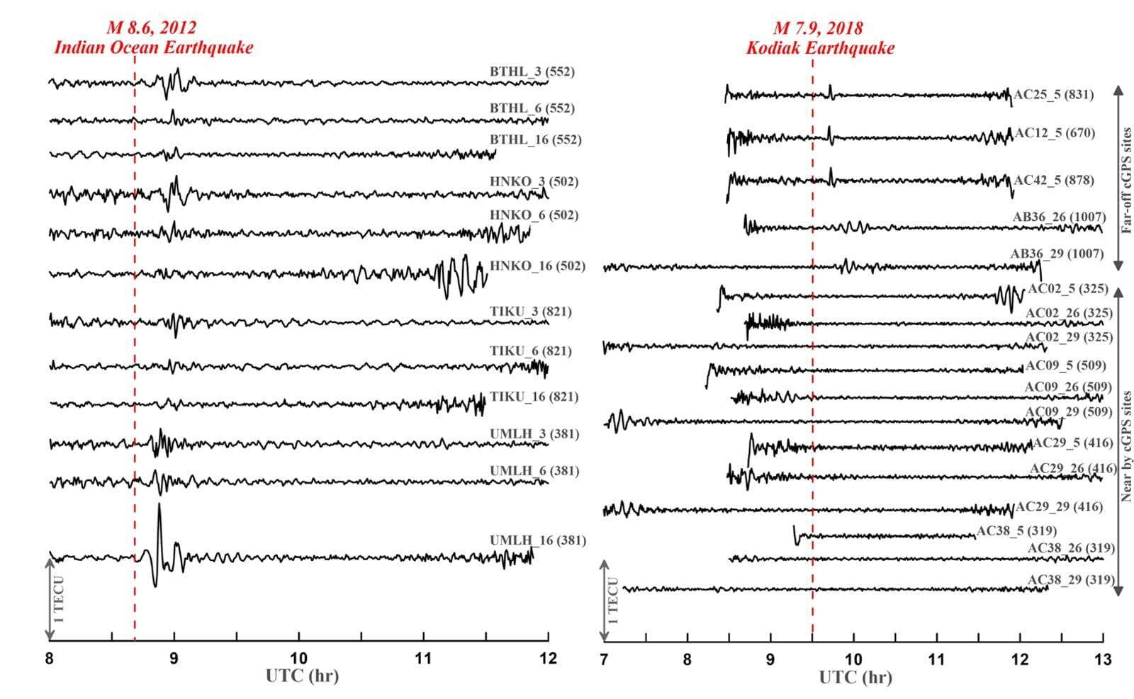
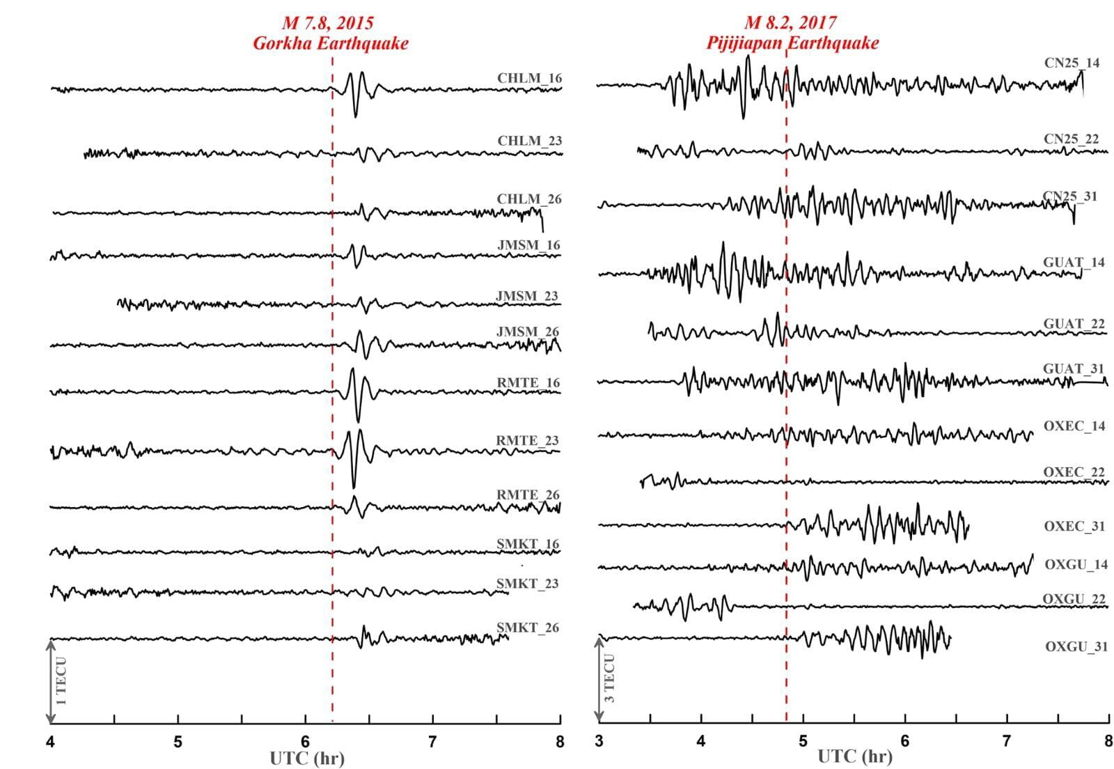
Ionospheric disturbances induced by various natural (e.g., earthquakes, volcanic eruption, thunderstorms, meteorite showers, solar eclipses) or anthropogenic (e.g., nuclear explosions, launching of space shuttles) processes can be detected through change in Total Electron Content (TEC) in the F-layer. These ionospheric perturbations can be captured by worldwide expanding geodetic (GNSS) networks, mainly during the day time, when the solar radiation ionizes the air molecules. However, during post-sunset period, strong ionospheric irregularities (known as Equatorial Plasma Bubbles, EPBs) develop due to the classical configuration for the Rayleigh-Taylor (R-T) instability that diffracts navigation and communication signals. Here we use various instances of ionospheric disturbances triggered by natural processes (e.g., earthquakes and volcanic eruption), in the recent decade to investigate the spatiotemporal and seasonal effects of ionospheric irregularities on the GNSS signals. Our study suggests that in the low-latitudinal region ...
Panda et al., 2019 MORE
Miscellaneous Works
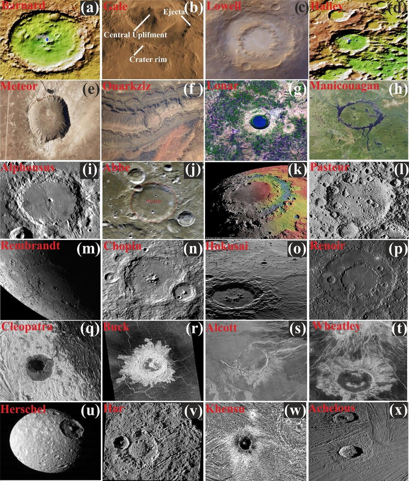
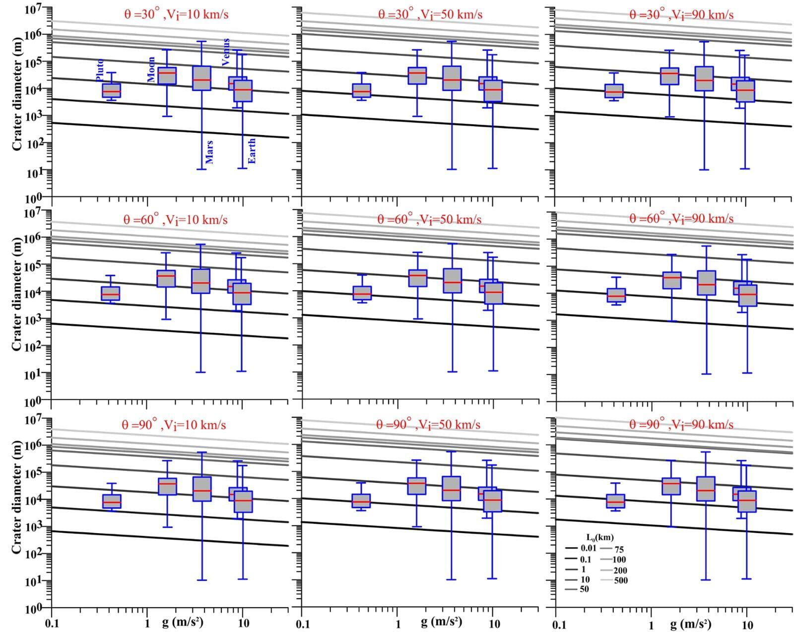
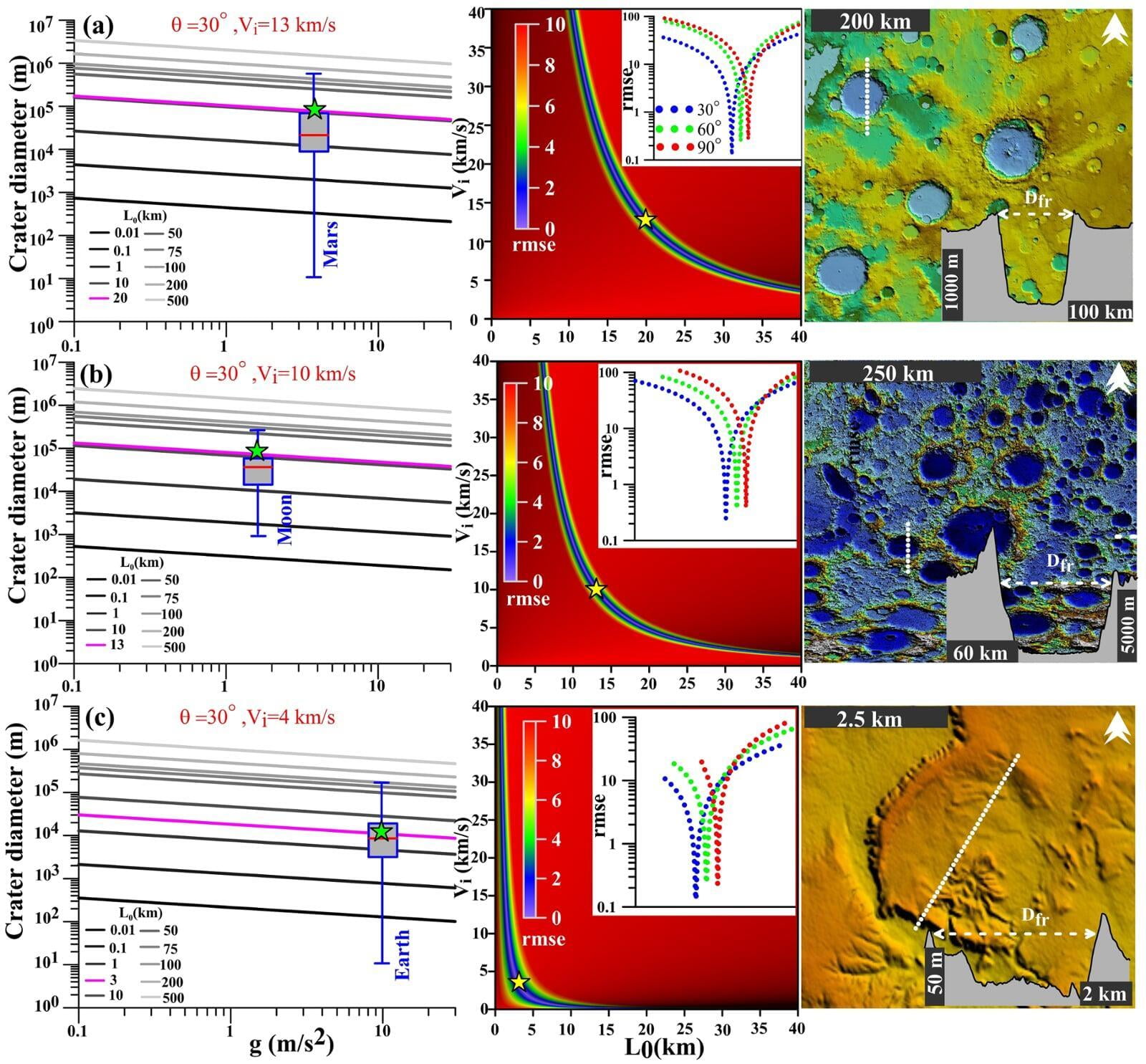
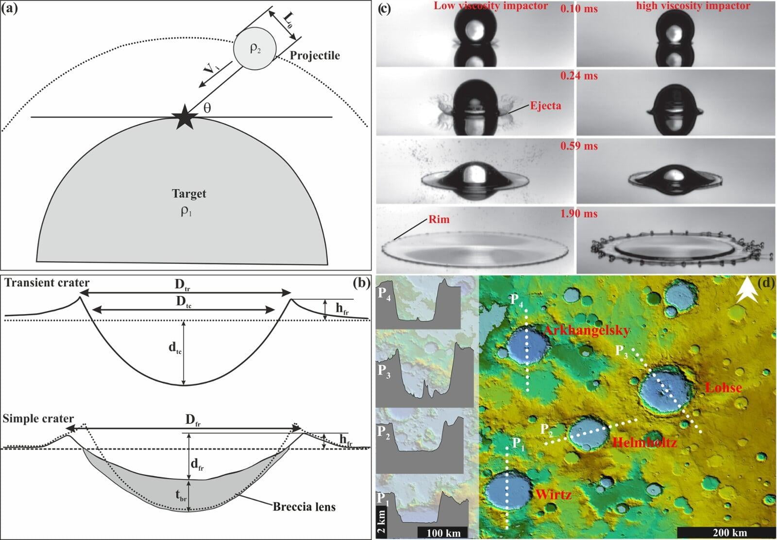
Surface gravity and crater diameter as proxies of extra-terrestrial impact
Impact cratering is a dominant geological process in the Solar system and is one of the frontier themes in planetary research. Here we explore the possible dependency of surface gravity and crater geometry in the natural and theoretical prediction from scaling factor of crater diameter using morphometric analysis. Theoretical model predicts a negative correlation between final crater diameter (Dfr) and gravitational acceleration of the target body (g). In our study, an inner solar system body reveals consistent correlation that demonstrates a fundamental relationship between Dfr and g, although such process may not be applicable if we consider outer solar system bodies. Our study indicates that impact-cratering process is primarily controlled by objects associated with asteroids belts. We also demonstrate that crater-diameter scaling can be used as the proxy for extra-terrestrial impact.
Kundu et al., 2019 MORE
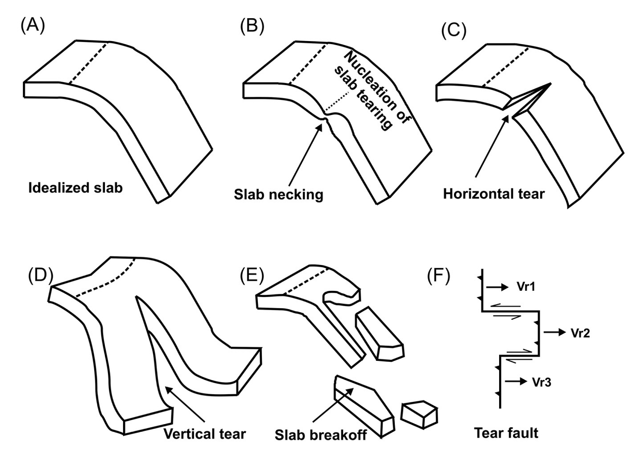
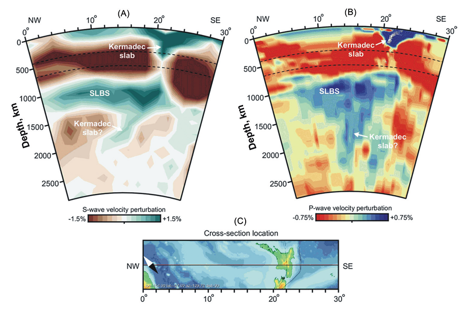
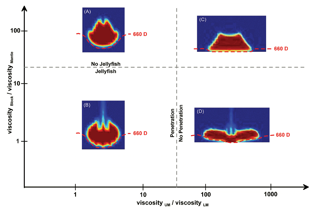
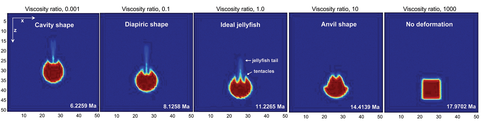
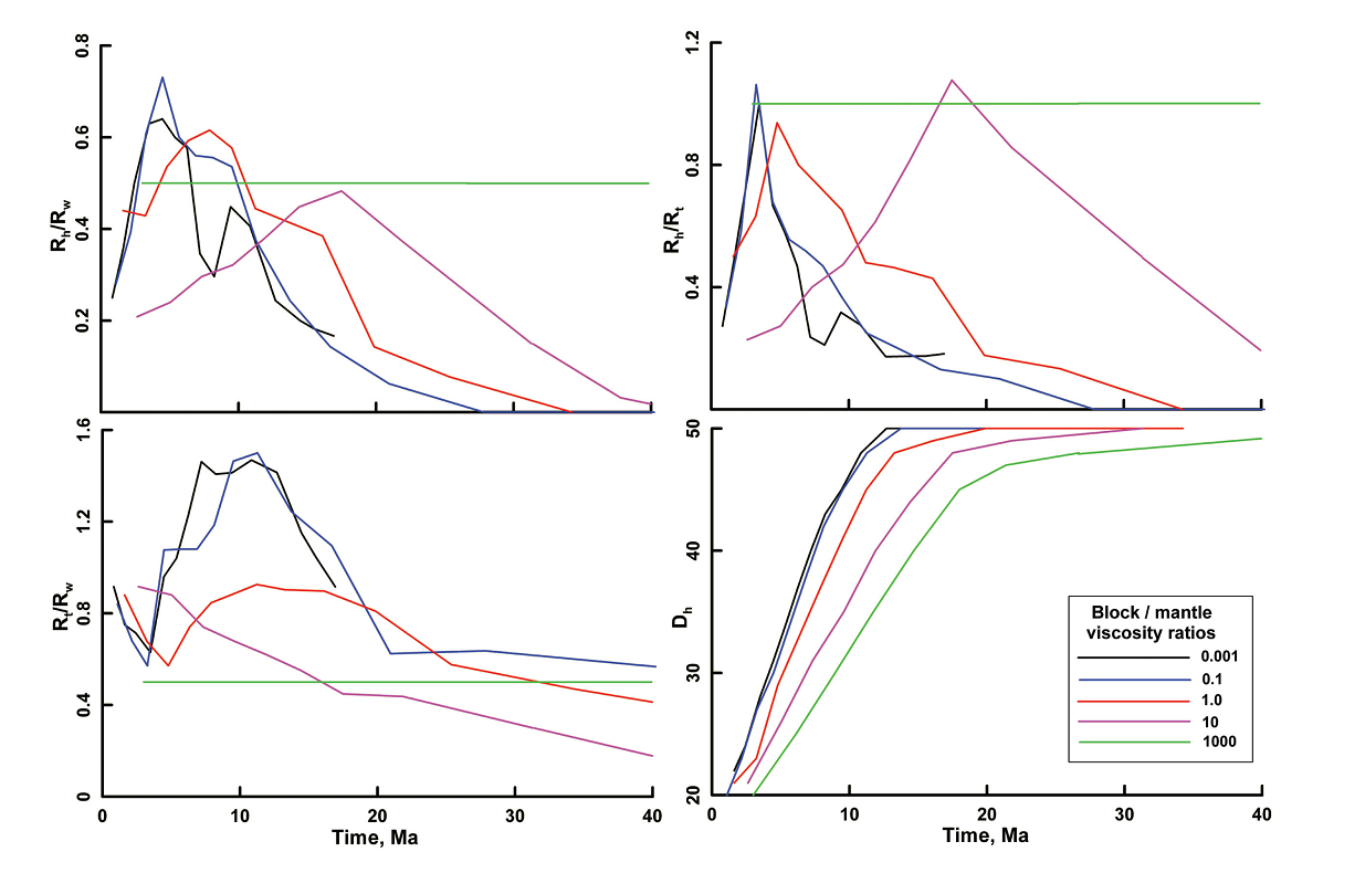
Dynamics of post-slab breakoff in convergent plate margins: a “jellyfish” Model
The Earth's subduction zones are characterized by a complex architecture of the subducting slabs, including necking, tearing, detachment from the surface plate, breakoff or ultimate slab loss, in contrast to the idealized models as popularly envisaged. Here we address the fate of the subducted slab after its breakoff by employing a simple two dimensional numerical modeling. Our results agree well with the tectonic scenario and geometric evolution of slab breakoff and reveal that during the sinking of broken slab fragments, the shape of the low viscosity slab (1-1000 times more viscous than the surrounding mantle) evolves into an inverted plume, similar to the “jellyfish” model proposed in some recent studies on deep subduction slabs. Our results confirm that the penetration criteria of the jellyfish into the lower mantle are primarily governed by the viscosity contrast between the lower to upper mantle. An evaluation of the various parameters suggest that the broken slab fragments may achieve a diverse type of morphology, correlating well with a similar diversity observed from high resolution seismic tomographic studies.
Kundu et al., 2011 MORE
Our Collaborators


School of Physics, Chemistry and Earth Sciences
Faculty of Sciences, Engineering and Technology
The University of Adelaide, South Australia


Helmholtz Centre Potsdam
GFZ German Research Centre for Geosciences


Media Coverage